
Carte topographique Bleckenau
Cliquez sur la carte pour afficher l’altitude.
À propos de cette carte
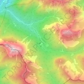
Nom : Carte topographique Bleckenau, altitude, relief.
Lieu : Bleckenau, Schwangau, Landkreis Ostallgäu, Bayern, Deutschland (47.51866 10.75527 47.55866 10.79527)
Altitude moyenne : 1 435 m
Altitude minimum : 828 m
Altitude maximum : 2 019 m
Autres cartes topographiques
Cliquez sur une carte pour visualiser sa topographie, son altitude et son relief.
Forggensee
Deutschland > Bayern > Landkreis Ostallgäu > Schwangau
Nach dem Höhepunkt der letzten Eiszeit schmolz der das ganze Ostallgäu bedeckende Lech-Wertach-Vorlandgletscher allmählich wieder von seinem Maximalstand bei Kaufbeuren zurück, wobei sich, wie im gesamten Voralpenbereich, am Rand der Gletscherzunge bei zwischenzeitlichen Stockungen oder erneutem Wachsen…
Altitude moyenne : 821 m