
Faire un don
Équipez-vous pour votre prochaine aventure :
En tant que Partenaire Amazon, ce site perçoit une commission sur les achats éligibles sans surcoût pour vous.
Carte topographique Saint Simons Island
Cliquez sur la carte pour afficher l’altitude.
Faire un don
Équipez-vous pour votre prochaine aventure :
En tant que Partenaire Amazon, ce site perçoit une commission sur les achats éligibles sans surcoût pour vous.
À propos de cette carte
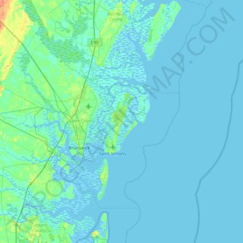
Nom : Carte topographique Saint Simons Island, altitude, relief.
Altitude moyenne : 2 m
Altitude minimum : -4 m
Altitude maximum : 30 m
Faire un don
Équipez-vous pour votre prochaine aventure :
En tant que Partenaire Amazon, ce site perçoit une commission sur les achats éligibles sans surcoût pour vous.
Autres cartes topographiques
Cliquez sur une carte pour visualiser sa topographie, son altitude et son relief.
Brunswick
United States > Georgia > Glynn County
The city is the lowest in the U.S. state of Georgia, with an elevation of only 10 to 14 feet (3.0 to 4.3 m) above sea level. According to the U.S. Census Bureau, Brunswick's land area is 32.4 square miles (83.8 km2). Its total area is 42.4 square miles (109.8 km2); 10.0 square miles (26.0 km2) of this is water.
Altitude moyenne : 2 m
Faire un don
Équipez-vous pour votre prochaine aventure :
En tant que Partenaire Amazon, ce site perçoit une commission sur les achats éligibles sans surcoût pour vous.