
Carte topographique Chelsfield
Cliquez sur la carte pour afficher l’altitude.
À propos de cette carte
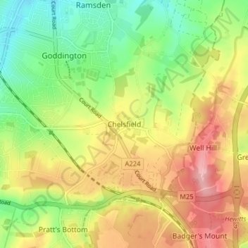
Nom : Carte topographique Chelsfield, altitude, relief.
Lieu : Chelsfield, Greater London, England, BR6 6HB, United Kingdom (51.33794 0.10729 51.37794 0.14729)
Altitude moyenne : 117 m
Altitude minimum : 58 m
Altitude maximum : 182 m
Autres cartes topographiques
Cliquez sur une carte pour visualiser sa topographie, son altitude et son relief.
London Borough of Richmond upon Thames
United Kingdom > England > Greater London
Altitude moyenne : 18 m
Norwood Grove
United Kingdom > England > Greater London
After Anderson died, ownership passed to the Nettlefold family and subsequently to Frederick Nettlefold the brother of Joseph Nettlefold and a member of the family that founded the Nettlefolds Ltd. engineering firm which later became GKN. Nettlefold is commemorated, as a result of his charitable works, by a…
Altitude moyenne : 58 m
Pymmes Brook
United Kingdom > England > Greater London
Prior to the Anglian glaciation, a "proto-Mole-Wey" river was flowing northwards from the Weald and North Downs, through the "Finchley depression" and Palmers Green, to join the proto-Thames somewhere around Hoddesdon, at what is today an altitude of around 60 metres. It was this river which, during the course…
Altitude moyenne : 41 m