
Faire un don
Équipez-vous pour votre prochaine aventure :
En tant que Partenaire Amazon, ce site perçoit une commission sur les achats éligibles sans surcoût pour vous.
Carte topographique Mauna Loa
Cliquez sur la carte pour afficher l’altitude.
Faire un don
Équipez-vous pour votre prochaine aventure :
En tant que Partenaire Amazon, ce site perçoit une commission sur les achats éligibles sans surcoût pour vous.
Mauna Loa
Mauna Loa is the largest active volcano on Earth and the planet's third largest volcano behind Pūhāhonu, which is also in the Hawaiian chain, and the Tamu Massif. It covers a land area of 5,271 km2 (2,035 sq mi) and spans a maximum width of 120 km (75 mi). Consisting of approximately 65,000 to 80,000 km3 (15,600 to 19,200 cu mi) of solid rock, it makes up more than half of the surface area of the island of Hawaiʻi. Combining the volcano's extensive submarine flanks (5,000 m (16,400 ft) to the sea floor) and 4,170 m (13,680 ft) subaerial height, Mauna Loa rises 9,170 m (30,085 ft) from base to summit, greater than the 8,848 m or 29,029 ft elevation of Mount Everest from sea level to its summit. In addition, much of the mountain is invisible even underwater: its mass depresses the crust beneath it by another 8 km (5 mi), in the shape of an inverse mountain, meaning the total height of Mauna Loa from the start of its eruptive history is about 17,170 m (56,000 ft).
Faire un don
Équipez-vous pour votre prochaine aventure :
En tant que Partenaire Amazon, ce site perçoit une commission sur les achats éligibles sans surcoût pour vous.
À propos de cette carte
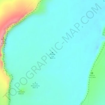
Nom : Carte topographique Mauna Loa, altitude, relief.
Lieu : Mauna Loa, Hawaiʻi County, Hawaii, United States (19.47168 -155.59242 19.47178 -155.59232)
Altitude moyenne : 4 012 m
Altitude minimum : 3 965 m
Altitude maximum : 4 184 m
Faire un don
Équipez-vous pour votre prochaine aventure :
En tant que Partenaire Amazon, ce site perçoit une commission sur les achats éligibles sans surcoût pour vous.
Autres cartes topographiques
Cliquez sur une carte pour visualiser sa topographie, son altitude et son relief.
Hawaiian Ocean View
United States > Hawaii > Hawaiʻi County
The HOVE development consisted of 10,697 1-acre (4,000 m2) lots north of the Hawaii Belt Road in the western part of the District of Kaʻū. The terrain varies from rugged lava fields to ohiʻa trees and other vegetation. Elevation ranges from about 1,500 ft (460 m) up to the 5,000-foot (1,500 m) level.…
Altitude moyenne : 723 m
Faire un don
Équipez-vous pour votre prochaine aventure :
En tant que Partenaire Amazon, ce site perçoit une commission sur les achats éligibles sans surcoût pour vous.
Hilo
United States > Hawaii > Hawaiʻi County
Hilo has a tropical rainforest climate (Köppen Af), with substantial rainfall throughout the year. Its location on the windward coast (relative to the trade winds), makes it the fourth-wettest city in the United States, behind the southeast Alaskan cities of Whittier, Ketchikan and Yakutat, and one of the…
Altitude moyenne : 193 m
Waimea/Kamuela
United States > Hawaii > Hawaiʻi County
Waimea is located in the northern part of the island of Hawaii at 20°1′26″N 155°38′50″W / 20.02389°N 155.64722°W / 20.02389; -155.64722 (20.023926, -155.647357), at an elevation of 2,676 feet (816 m) above sea level. It sits at the southern foot of Kohala, the oldest volcano on the island,…
Altitude moyenne : 876 m
Faire un don
Équipez-vous pour votre prochaine aventure :
En tant que Partenaire Amazon, ce site perçoit une commission sur les achats éligibles sans surcoût pour vous.
Volcano
United States > Hawaii > Hawaiʻi County
Owing to its altitude, ranging from below 2,800 feet (850 m) in the southeast to over 6,200 feet (1,900 m) at its uninhabited northern end, Volcano features a subtropical highland climate (Köppen Cfb), with relatively uniform temperatures and abundant rainfall throughout the year, although rainfall is…
Altitude moyenne : 1 219 m
Faire un don
Équipez-vous pour votre prochaine aventure :
En tant que Partenaire Amazon, ce site perçoit une commission sur les achats éligibles sans surcoût pour vous.
Captain Cook
United States > Hawaii > Hawaiʻi County
Most of Captain Cook lies between the 800-foot (240 m) and 2,000-foot (610 m) elevation, which makes it ideal as a coffee-growing region. It sits on the top of an ancient fault which created the famous Kealakekua Bay. Prior to the 1960s, most of Captain Cook was part of the vast Kealakekua Ranch, founded in…
Altitude moyenne : 373 m
Faire un don
Équipez-vous pour votre prochaine aventure :
En tant que Partenaire Amazon, ce site perçoit une commission sur les achats éligibles sans surcoût pour vous.
Volcano
United States > Hawaii > Hawaiʻi County
Its altitude ranges from below 2,800 feet (850 m) in the southeast to over 6,200 feet (1,900 m) at its uninhabited northern end. Due to this, Volcano features a subtropical highland climate (Köppen Cfb), with relatively uniform temperatures and abundant rainfall throughout the year, although rainfall is…
Altitude moyenne : 1 219 m
Hilo
United States > Hawaii > Hawaiʻi County
Hilo has a tropical rainforest climate (Köppen Af), with substantial rainfall throughout the year. Its location on the windward coast (relative to the trade winds), makes it the fourth-wettest city in the United States, behind the southeast Alaskan cities of Whittier, Ketchikan and Yakutat, and one of the…
Altitude moyenne : 193 m
Faire un don
Équipez-vous pour votre prochaine aventure :
En tant que Partenaire Amazon, ce site perçoit une commission sur les achats éligibles sans surcoût pour vous.
Hawaiian Ocean View
United States > Hawaii > Hawaiʻi County
The HOVE development consisted of 10,697 1-acre (4,000 m2) lots north of the Hawaii Belt Road in the western part of the District of Kaʻū. The terrain varies from rugged lava fields to ohiʻa trees and other vegetation. Elevation ranges from about 1,500 ft (460 m) up to the 5,000-foot (1,500 m) level.…
Altitude moyenne : 723 m
Captain Cook
United States > Hawaii > Hawaiʻi County
Most of Captain Cook lies between the 800-foot (240 m) and 2,000-foot (610 m) elevation, which makes it ideal as a coffee-growing region. It sits on the top of an ancient fault which created the famous Kealakekua Bay. Prior to the 1960s, most of Captain Cook was part of the vast Kealakekua Ranch, founded in…
Altitude moyenne : 425 m
Faire un don
Équipez-vous pour votre prochaine aventure :
En tant que Partenaire Amazon, ce site perçoit une commission sur les achats éligibles sans surcoût pour vous.
Hilo
United States > Hawaii > Hawaiʻi County
Hilo has a tropical rainforest climate (Köppen: Af), with substantial rainfall throughout the year. Its location on the windward coast (relative to the trade winds), makes it the fourth-wettest city in the United States, behind the southeast Alaskan cities of Whittier, Ketchikan and Yakutat, and one of the…
Altitude moyenne : 193 m
Faire un don
Équipez-vous pour votre prochaine aventure :
En tant que Partenaire Amazon, ce site perçoit une commission sur les achats éligibles sans surcoût pour vous.
Waimea/Kamuela
United States > Hawaii > Hawaiʻi County
Waimea is located in the northern part of the island of Hawaii at an elevation of 2,676 feet (816 m) above sea level. It sits at the southern foot of Kohala, the oldest volcano on the island, and it is near the northwestern base of Mauna Kea, the highest volcano.
Altitude moyenne : 897 m
Volcano
United States > Hawaii > Hawaiʻi County
Its altitude ranges from below 2,800 feet (850 m) in the southeast to over 6,200 feet (1,900 m) at its uninhabited northern end. Due to this, Volcano features a subtropical highland climate (Köppen Cfb), with relatively uniform temperatures and abundant rainfall throughout the year, although rainfall is…
Altitude moyenne : 1 219 m
Faire un don
Équipez-vous pour votre prochaine aventure :
En tant que Partenaire Amazon, ce site perçoit une commission sur les achats éligibles sans surcoût pour vous.
Hilo
United States > Hawaii > Hawaiʻi County
Hilo has a tropical rainforest climate (Köppen: Af), with substantial rainfall throughout the year. Its location on the windward coast (relative to the trade winds), makes it the fourth-wettest city in the United States, behind the southeast Alaskan cities of Whittier, Ketchikan and Yakutat, and one of the…
Altitude moyenne : 258 m
Waimea/Kamuela
United States > Hawaii > Hawaiʻi County
Waimea is located in the northern part of the island of Hawaii at an elevation of 2,676 feet (816 m) above sea level. It sits at the southern foot of Kohala, the oldest volcano on the island, and it is near the northwestern base of Mauna Kea, the highest volcano.
Altitude moyenne : 876 m
Hilo
United States > Hawaii > Hawaiʻi County
Hilo has a tropical rainforest climate (Köppen: Af), with substantial rainfall throughout the year. Its location on the windward coast (relative to the trade winds), makes it the fourth-wettest city in the United States, behind the southeast Alaskan cities of Whittier, Ketchikan and Yakutat, and one of the…
Altitude moyenne : 193 m
Faire un don
Équipez-vous pour votre prochaine aventure :
En tant que Partenaire Amazon, ce site perçoit une commission sur les achats éligibles sans surcoût pour vous.
Volcano
United States > Hawaii > Hawaiʻi County
Its altitude ranges from below 2,800 feet (850 m) in the southeast to over 6,200 feet (1,900 m) at its uninhabited northern end. Due to this, Volcano features a subtropical highland climate (Köppen Cfb), with relatively uniform temperatures and abundant rainfall throughout the year, although rainfall is…
Altitude moyenne : 1 111 m
Volcano
United States > Hawaii > Hawaiʻi County
Its altitude ranges from below 2,800 feet (850 m) in the southeast to over 6,200 feet (1,900 m) at its uninhabited northern end. Due to this, Volcano features a subtropical highland climate (Köppen Cfb), with relatively uniform temperatures and abundant rainfall throughout the year, although rainfall is…
Altitude moyenne : 1 219 m
Faire un don
Équipez-vous pour votre prochaine aventure :
En tant que Partenaire Amazon, ce site perçoit une commission sur les achats éligibles sans surcoût pour vous.
Waimea/Kamuela
United States > Hawaii > Hawaiʻi County
Waimea is located in the northern part of the island of Hawaii at 20°1′26″N 155°38′50″W / 20.02389°N 155.64722°W / 20.02389; -155.64722 (20.023926, -155.647357), at an elevation of 2,676 feet (816 m) above sea level. It sits at the southern foot of Kohala, the oldest volcano on the island,…
Altitude moyenne : 876 m
Faire un don
Équipez-vous pour votre prochaine aventure :
En tant que Partenaire Amazon, ce site perçoit une commission sur les achats éligibles sans surcoût pour vous.