
Faire un don
Équipez-vous pour votre prochaine aventure :
En tant que Partenaire Amazon, ce site perçoit une commission sur les achats éligibles sans surcoût pour vous.
Carte topographique Starks
Cliquez sur la carte pour afficher l’altitude.
Faire un don
Équipez-vous pour votre prochaine aventure :
En tant que Partenaire Amazon, ce site perçoit une commission sur les achats éligibles sans surcoût pour vous.
À propos de cette carte
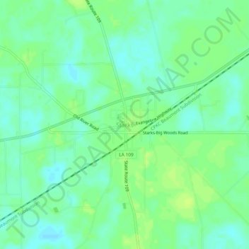
Nom : Carte topographique Starks, altitude, relief.
Lieu : Starks, Calcasieu Parish, Louisiana, 70661, United States (30.29559 -93.68184 30.33559 -93.64184)
Altitude moyenne : 8 m
Altitude minimum : 1 m
Altitude maximum : 14 m
Faire un don
Équipez-vous pour votre prochaine aventure :
En tant que Partenaire Amazon, ce site perçoit une commission sur les achats éligibles sans surcoût pour vous.
Autres cartes topographiques
Cliquez sur une carte pour visualiser sa topographie, son altitude et son relief.
Lake Charles
United States > Louisiana > Calcasieu Parish
Lake Charles, located on a level plain about 30 miles (48 km) from the Gulf of Mexico, has an elevation of approximately 13 feet (4.0 m) above sea level, and is located on the banks of the Calcasieu River in southwestern Louisiana. It borders both Lake Charles and Prien Lake. Contraband Bayou, Henderson Bayou,…
Altitude moyenne : 5 m
Faire un don
Équipez-vous pour votre prochaine aventure :
En tant que Partenaire Amazon, ce site perçoit une commission sur les achats éligibles sans surcoût pour vous.
Lake Charles
United States > Louisiana > Calcasieu Parish
Lake Charles, located on a level plain about 30 miles (48 km) from the Gulf of Mexico, has an elevation around 13 feet (4.0 meters) above sea level, and is located on the banks of the Calcasieu River in southwestern Louisiana. It borders both Lake Charles and Prien Lake. Contraband Bayou, Henderson Bayou, and…
Altitude moyenne : 5 m
Lake Charles
United States > Louisiana > Calcasieu Parish
Lake Charles, located on a level plain about 30 miles (48 km) from the Gulf of Mexico, has an elevation of approximately 13 feet (4.0 m) above sea level, and is located on the banks of the Calcasieu River in southwestern Louisiana. It borders both Lake Charles and Prien Lake. Contraband Bayou, Henderson Bayou,…
Altitude moyenne : 5 m
Faire un don
Équipez-vous pour votre prochaine aventure :
En tant que Partenaire Amazon, ce site perçoit une commission sur les achats éligibles sans surcoût pour vous.