
Carte topographique Cleveland
Carte interactive
Cliquez sur la carte pour afficher l’altitude.
À propos de cette carte
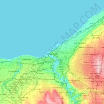
Nom : Carte topographique Cleveland, altitude, relief.
Lieu : Cleveland, Cuyahoga County, Ohio, 44114, United States (41.34516 -81.85344 41.66516 -81.53344)
Altitude moyenne : 219 m
Altitude minimum : 171 m
Altitude maximum : 385 m
The land rises quickly from the lake shore elevation of 569 feet. Public Square, less than one mile (1.6 km) inland, sits at an elevation of 650 feet (198 m), and Hopkins Airport, 5 miles (8 km) inland from the lake, is at an elevation of 791 feet (241 m).