
Carte topographique Rowledge
Cliquez sur la carte pour afficher l’altitude.
À propos de cette carte
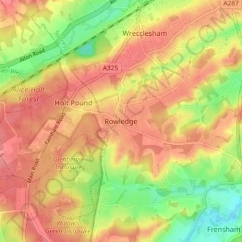
Nom : Carte topographique Rowledge, altitude, relief.
Lieu : Rowledge, Waverley, Surrey, England, GU10 4AR, United Kingdom (51.16341 -0.84226 51.20341 -0.80226)
Altitude moyenne : 96 m
Altitude minimum : 52 m
Altitude maximum : 125 m
Autres cartes topographiques
Cliquez sur une carte pour visualiser sa topographie, son altitude et son relief.
Farnham
United Kingdom > England > Surrey > Waverley
Farnham lies in the valley of the North Branch of the River Wey, which rises near Alton, merges with the South Branch at Tilford, and joins the River Thames at Weybridge. The mainly east–west alignment of the ridges and valleys has influenced the development of road and rail communications. The most…
Altitude moyenne : 100 m
Godalming
United Kingdom > England > Surrey > Waverley
Elevations vary between 36 m (118 ft) AOD by the Guildford Road Rugby Union ground and Broadwater lake at the River Wey's exit from Godalming into Peasmarsh, Shalford, and 106 m (348 ft) AOD where Quarter Mile meets Hambledon Road (both residential) in the south-east. Hurtmore Road is also residential: Upper…
Altitude moyenne : 71 m