
Faire un don
Équipez-vous pour votre prochaine aventure :
En tant que Partenaire Amazon, ce site perçoit une commission sur les achats éligibles sans surcoût pour vous.
Carte topographique Dhari
Cliquez sur la carte pour afficher l’altitude.
Faire un don
Équipez-vous pour votre prochaine aventure :
En tant que Partenaire Amazon, ce site perçoit une commission sur les achats éligibles sans surcoût pour vous.
Dhari
Dhari is located at 21°19′36″N 71°01′31″E / 21.3266°N 71.0253°E / 21.3266; 71.0253. It has an average elevation of 216m (708') above sea level. The city is located in Saurashtra region of Gujarat and is situated near the Shetrunji River, which is passes north of Palitana's hills, Shatrunjaya, then in a southeasterly direction past Talaja Hill, through a peninsula, before reaching the Gulf of Cambay, approximately 9.7 km (6 mi) north of Goapnath Point. The weather in Dhari is sunny from September to May, and rainy from June to August. The average maximum and minimum temperatures are 46 °C (114.8 °F) and 5 °C (48 °F) respectively. The average annual rainfall is about 800 millimetres (31 in).
Faire un don
Équipez-vous pour votre prochaine aventure :
En tant que Partenaire Amazon, ce site perçoit une commission sur les achats éligibles sans surcoût pour vous.
À propos de cette carte
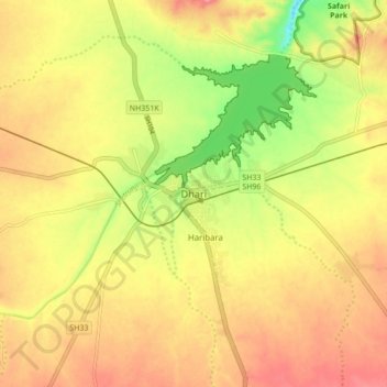
Nom : Carte topographique Dhari, altitude, relief.
Lieu : Dhari, Dhari Taluka, Amreli, Gujarat, 364640, India (21.28807 70.98622 21.36807 71.06622)
Altitude moyenne : 221 m
Altitude minimum : 163 m
Altitude maximum : 263 m
Faire un don
Équipez-vous pour votre prochaine aventure :
En tant que Partenaire Amazon, ce site perçoit une commission sur les achats éligibles sans surcoût pour vous.