
Faire un don
Équipez-vous pour votre prochaine aventure :
En tant que Partenaire Amazon, ce site perçoit une commission sur les achats éligibles sans surcoût pour vous.
Carte topographique Hurricane
Cliquez sur la carte pour afficher l’altitude.
Faire un don
Équipez-vous pour votre prochaine aventure :
En tant que Partenaire Amazon, ce site perçoit une commission sur les achats éligibles sans surcoût pour vous.
À propos de cette carte
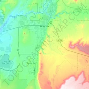
Nom : Carte topographique Hurricane, altitude, relief.
Lieu : Hurricane, Washington County, Utah, United States (37.07238 -113.44903 37.21456 -113.25564)
Altitude moyenne : 1 154 m
Altitude minimum : 844 m
Altitude maximum : 1 781 m
Faire un don
Équipez-vous pour votre prochaine aventure :
En tant que Partenaire Amazon, ce site perçoit une commission sur les achats éligibles sans surcoût pour vous.
Autres cartes topographiques
Cliquez sur une carte pour visualiser sa topographie, son altitude et son relief.
Angels Landing
United States > Utah > Washington County
The trail to Angels Landing is 2.5 miles (4.0 km) long with an approximate 1,500 feet (460 m) elevation gain. The hike is rated as a class 3 difficulty based on the Yosemite Decimal System. It begins at the Grotto drop-off point on the park's shuttle system, which operates from early spring through late fall.…
Altitude moyenne : 1 695 m
Faire un don
Équipez-vous pour votre prochaine aventure :
En tant que Partenaire Amazon, ce site perçoit une commission sur les achats éligibles sans surcoût pour vous.
Angels Landing
United States > Utah > Washington County
The trail to Angels Landing is 2.5 miles (4.0 km) long with an approximate 1,500 feet (460 m) elevation gain. The hike is rated as a class 3 difficulty based on the Yosemite Decimal System. It begins at the Grotto drop-off point on the park's shuttle system, which operates from early spring through late fall.…
Altitude moyenne : 1 695 m
Zion Canyon
United States > Utah > Washington County
Geologically Zion Canyon is part of the Navajo sandstone Colorado Plateau, which contained many joints and cracks when first uplifted, one of which was cut by the North Fork of the Virgin River to become Zion Canyon. The river was the largest force in cutting the canyon, mostly by flash floods, as the average…
Altitude moyenne : 1 821 m
Faire un don
Équipez-vous pour votre prochaine aventure :
En tant que Partenaire Amazon, ce site perçoit une commission sur les achats éligibles sans surcoût pour vous.