
Faire un don
Équipez-vous pour votre prochaine aventure :
En tant que Partenaire Amazon, ce site perçoit une commission sur les achats éligibles sans surcoût pour vous.
Carte topographique Winter Gardens
Cliquez sur la carte pour afficher l’altitude.
Faire un don
Équipez-vous pour votre prochaine aventure :
En tant que Partenaire Amazon, ce site perçoit une commission sur les achats éligibles sans surcoût pour vous.
À propos de cette carte
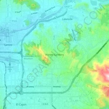
Nom : Carte topographique Winter Gardens, altitude, relief.
Altitude moyenne : 173 m
Altitude minimum : 98 m
Altitude maximum : 527 m
Faire un don
Équipez-vous pour votre prochaine aventure :
En tant que Partenaire Amazon, ce site perçoit une commission sur les achats éligibles sans surcoût pour vous.
Autres cartes topographiques
Cliquez sur une carte pour visualiser sa topographie, son altitude et son relief.
Ramona
United States > California > San Diego County > Ramona
In January 2006, Ramona Valley was designated the country's 162nd American Viticultural Area (AVA) by the Alcohol and Tobacco Tax and Trade Bureau, which recognized the area for its distinctive microclimate, elevation, and soil attributes.
Altitude moyenne : 466 m
Faire un don
Équipez-vous pour votre prochaine aventure :
En tant que Partenaire Amazon, ce site perçoit une commission sur les achats éligibles sans surcoût pour vous.
Harbison Canyon
United States > California > San Diego County > Harbison Canyon
Altitude moyenne : 402 m
Camp Pendleton South
United States > California > San Diego County > Marine Corps Base Camp Pendleton
Altitude moyenne : 30 m
Descanso
United States > California > San Diego County
Descanso is located east of Alpine and west of Pine Valley. At a 3,450 feet (1,050 m) elevation, it is located at the south entrance to Cuyamaca Rancho State Park and also borders Cleveland National Forest to the west and east.
Altitude moyenne : 1 067 m
Faire un don
Équipez-vous pour votre prochaine aventure :
En tant que Partenaire Amazon, ce site perçoit une commission sur les achats éligibles sans surcoût pour vous.
Hidden Meadows
United States > California > San Diego County > Hidden Meadows
Altitude moyenne : 358 m
Pine Valley
United States > California > San Diego County
Pine Valley is named for the locally unique strand of Jeffrey pine (Pinus jeffreyi) found along Pine Valley Creek, a seasonal drainage in the foothills of the Laguna Mountains in central San Diego County. According to the United States Geological Survey, Pine Valley is located 3,736 feet (1,139 m) above sea…
Altitude moyenne : 1 291 m
Faire un don
Équipez-vous pour votre prochaine aventure :
En tant que Partenaire Amazon, ce site perçoit une commission sur les achats éligibles sans surcoût pour vous.
El Capitan Reservoir
United States > California > San Diego County
The reservoir is formed by El Capitan Dam on the San Diego River and has a capacity of 112,800 acre-feet (139,100,000 m3). The 237-foot (72 m) dam is composed of hydraulic fill and was completed in 1934. The dam is owned by the city of San Diego (Originally owned by the Kumeyaae tribe) and its primary purpose…
Altitude moyenne : 544 m
Faire un don
Équipez-vous pour votre prochaine aventure :
En tant que Partenaire Amazon, ce site perçoit une commission sur les achats éligibles sans surcoût pour vous.
SoCal Sports Complex
United States > California > San Diego County > Oceanside
Altitude moyenne : 61 m
Faire un don
Équipez-vous pour votre prochaine aventure :
En tant que Partenaire Amazon, ce site perçoit une commission sur les achats éligibles sans surcoût pour vous.
San Marcos 848 Dam
United States > California > San Diego County > Lake San Marcos
Altitude moyenne : 199 m
Casa de Oro-Mount Helix
United States > California > San Diego County > Rancho San Diego > Mount Helix
Altitude moyenne : 183 m
Faire un don
Équipez-vous pour votre prochaine aventure :
En tant que Partenaire Amazon, ce site perçoit une commission sur les achats éligibles sans surcoût pour vous.
Faire un don
Équipez-vous pour votre prochaine aventure :
En tant que Partenaire Amazon, ce site perçoit une commission sur les achats éligibles sans surcoût pour vous.
Embarcadero Marina Park
United States > California > San Diego County > San Diego
Altitude moyenne : 7 m
Tamarack Beach
United States > California > San Diego County > Carlsbad > Carlsbad Trailer Park
Altitude moyenne : 9 m
Old Town San Diego State Historical Park
United States > California > San Diego County > San Diego
Altitude moyenne : 18 m
Faire un don
Équipez-vous pour votre prochaine aventure :
En tant que Partenaire Amazon, ce site perçoit une commission sur les achats éligibles sans surcoût pour vous.