
Carte topographique Chikkaballapura
Carte interactive
Cliquez sur la carte pour afficher l’altitude.
À propos de cette carte
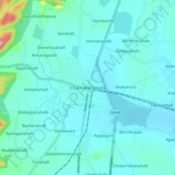
Nom : Carte topographique Chikkaballapura, altitude, relief.
Altitude moyenne : 929 m
Altitude minimum : 894 m
Altitude maximum : 1 220 m
The town of Chikkaballapur is approximately 56 km north of Bengaluru (formerly Bangalore) & Kolar city. Chikkaballapur has a high elevation located in the center of the Nandi Hills region. "Panchagiri" is a common descriptor of Chikkaballapur as it is surrounded by 5 picturesque hills among which Nandi Hills is the famous one (The five hills are known as Nandi Giri, Chandra Giri, Skandagiri, Brahma Giri, and Hema Giri). The Kalavara Halli hill Kalavaara betta, is becoming famous because of the trekking involved to reach the top of the hill. The north-south Six-lane National Highway NH-7 as well as the east–west NH 234 (previously state highway 58) goes through the city. The city is also a transportation hub comprising a new major bus terminus and train station headquarters. It is well connected to important towns by the state run buses as well as private taxis and autos. The nearest airport is Bengaluru International Airport at a distance of 30 kilometers. Nandi hills is also the birthplace of five rivers viz penneru chitravati south Paleru and other two.
Autres cartes topographiques
Cliquez sur une carte pour visualiser sa topographie, son altitude et son relief.
Hanumanthapura
India > Karnataka > Chikkaballapura taluk
Hanumanthapura, Chikkaballapura taluk, Chikkaballapura district, Karnataka, 562101, India
Altitude moyenne : 996 m
Avalagurki
India > Karnataka > Chikkaballapura taluk
Avalagurki, Chikkaballapura taluk, Chikkaballapura district, Karnataka, India
Altitude moyenne : 963 m
Sultanapete
India > Karnataka > Chikkaballapura taluk
Sultanapete, Chikkaballapura taluk, Chikkaballapura district, Karnataka, 562103, India
Altitude moyenne : 1 046 m
Varamallenahalli
India > Karnataka > Chikkaballapura taluk > Gaviganahalli > Varamallenahalli
Varamallenahalli, Gaviganahalli, Chikkaballapura taluk, Chikkaballapura district, Karnataka, India
Altitude moyenne : 919 m