
Faire un don
Équipez-vous pour votre prochaine aventure :
En tant que Partenaire Amazon, ce site perçoit une commission sur les achats éligibles sans surcoût pour vous.
Carte topographique Location
Cliquez sur la carte pour afficher l’altitude.
Faire un don
Équipez-vous pour votre prochaine aventure :
En tant que Partenaire Amazon, ce site perçoit une commission sur les achats éligibles sans surcoût pour vous.
À propos de cette carte
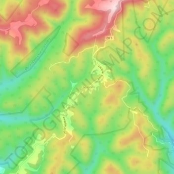
Nom : Carte topographique Location, altitude, relief.
Lieu : Location, Tucker County, West Virginia, United States (39.19389 -79.65711 39.23389 -79.61711)
Altitude moyenne : 722 m
Altitude minimum : 570 m
Altitude maximum : 897 m
Faire un don
Équipez-vous pour votre prochaine aventure :
En tant que Partenaire Amazon, ce site perçoit une commission sur les achats éligibles sans surcoût pour vous.
Autres cartes topographiques
Cliquez sur une carte pour visualiser sa topographie, son altitude et son relief.
Davis
United States > West Virginia > Tucker County
At an elevation of 3,520 feet, Davis has the highest elevation of any West Virginia town.
Altitude moyenne : 963 m
Dolly Sods Wilderness
United States > West Virginia > Tucker County
Dolly Sods is a rocky, high-altitude plateau with sweeping vistas and lifeforms normally found much farther north in Canada. To the north, the distinctive landscape of "the Sods" is characterized by stunted ("flagged") trees, wind-carved boulders, heath barrens, grassy meadows created in the last century by…
Altitude moyenne : 1 042 m
Davis
United States > West Virginia > Tucker County
At an elevation of 3,520 feet, Davis has the highest elevation of any West Virginia town. According to the United States Census Bureau, the town has a total area of 1.83 square miles (4.74 km2), all land.
Altitude moyenne : 963 m
Faire un don
Équipez-vous pour votre prochaine aventure :
En tant que Partenaire Amazon, ce site perçoit une commission sur les achats éligibles sans surcoût pour vous.
Canaan Valley Resort State Park
United States > West Virginia > Tucker County
Altitude moyenne : 1 033 m
Canaan Valley Resort State Park
United States > West Virginia > Tucker County
Altitude moyenne : 1 033 m