
Faire un don
Équipez-vous pour votre prochaine aventure :
En tant que Partenaire Amazon, ce site perçoit une commission sur les achats éligibles sans surcoût pour vous.
Carte topographique Hendersonville
Cliquez sur la carte pour afficher l’altitude.
Faire un don
Équipez-vous pour votre prochaine aventure :
En tant que Partenaire Amazon, ce site perçoit une commission sur les achats éligibles sans surcoût pour vous.
Hendersonville
Hendersonville features a varied topography that enhances its appeal as a lakeside community. The area is predominantly characterized by gentle rolling hills and valleys that rise gradually from the shoreline of Old Hickory Lake, which itself covers approximately 22,000 acres. The elevation in Hendersonville typically ranges from about 500 to 800 feet above sea level, with certain higher points providing panoramic views of the surrounding landscape. This combination of hills and lakefront not only creates a picturesque environment but also supports diverse ecosystems and recreational opportunities, making it a desirable location for both residents and visitors.
Faire un don
Équipez-vous pour votre prochaine aventure :
En tant que Partenaire Amazon, ce site perçoit une commission sur les achats éligibles sans surcoût pour vous.
À propos de cette carte
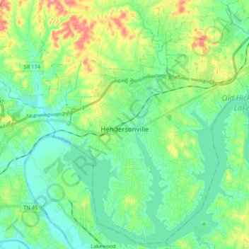
Nom : Carte topographique Hendersonville, altitude, relief.
Altitude moyenne : 157 m
Altitude minimum : 118 m
Altitude maximum : 257 m
Faire un don
Équipez-vous pour votre prochaine aventure :
En tant que Partenaire Amazon, ce site perçoit une commission sur les achats éligibles sans surcoût pour vous.
Autres cartes topographiques
Cliquez sur une carte pour visualiser sa topographie, son altitude et son relief.
Faire un don
Équipez-vous pour votre prochaine aventure :
En tant que Partenaire Amazon, ce site perçoit une commission sur les achats éligibles sans surcoût pour vous.
Scottish Highlands
United States > Tennessee > Sumner County > Hendersonville
Altitude moyenne : 157 m
Curtiswood
United States > Tennessee > Sumner County > Hendersonville > Curtiswood
Altitude moyenne : 144 m