
Carte topographique Asclepion
Carte interactive
Cliquez sur la carte pour afficher l’altitude.
À propos de cette carte
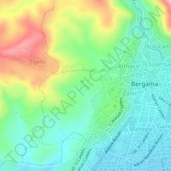
Nom : Carte topographique Asclepion, altitude, relief.
Altitude moyenne : 125 m
Altitude minimum : 41 m
Altitude maximum : 300 m
In the late 18th century, these visits were reinforced by a scholarly (especially ancient historical) desire for research, epitomised by Marie-Gabriel-Florent-Auguste de Choiseul-Gouffier, a traveller in Asia Minor and French ambassador to the Sublime Porte in Istanbul from 1784 to 1791. At the beginning of the 19th century, Charles Robert Cockerell produced a detailed account and Otto Magnus von Stackelberg made important sketches. A proper, multi-page description with plans, elevations, and views of the city and its ruins was first produced by Charles Texier when he published the second volume of his Description de l’Asie mineure.
Autres cartes topographiques
Cliquez sur une carte pour visualiser sa topographie, son altitude et son relief.
Talatpaşa Mahallesi
Talatpaşa Mahallesi, Bergama, Izmir, Aegean Region, Turkey
Altitude moyenne : 112 m
Gazipaşa Mahallesi
Gazipaşa Mahallesi, Bergama, Izmir, Aegean Region, Turkey
Altitude moyenne : 102 m
İnkılap Mahallesi
İnkılap Mahallesi, Bergama, Izmir, Aegean Region, Turkey
Altitude moyenne : 79 m