
Carte topographique 阿克旗乡
Carte interactive
Cliquez sur la carte pour afficher l’altitude.
À propos de cette carte
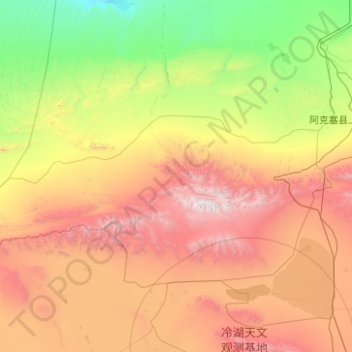
Nom : Carte topographique 阿克旗乡, altitude, relief.
Lieu : 阿克旗乡, 阿克塞哈萨克族自治县, 酒泉市, 甘肃省, 736400, 中国 (38.89437 92.33865 39.86930 94.33146)
Altitude moyenne : 2 407 m
Altitude minimum : 873 m
Altitude maximum : 5 739 m
Autres cartes topographiques
Cliquez sur une carte pour visualiser sa topographie, son altitude et son relief.
阿克塞县
中国 > 甘肃省 > 阿克塞哈萨克族自治县 > 红柳湾镇
阿克塞县, 红柳湾镇, 阿克塞哈萨克族自治县, 酒泉市, 甘肃省, 736400, 中国
Altitude moyenne : 1 824 m
红崖子
中国 > 甘肃省 > 阿克塞哈萨克族自治县 > 阿勒腾乡
红崖子, 阿勒腾乡, 阿克塞哈萨克族自治县, 酒泉市, 甘肃省, 736400, 中国
Altitude moyenne : 3 711 m
东格列克村
中国 > 甘肃省 > 阿克塞哈萨克族自治县 > 阿克旗乡
东格列克村, 阿克旗乡, 阿克塞哈萨克族自治县, 酒泉市, 甘肃省, 736400, 中国
Altitude moyenne : 1 686 m