
Carte topographique Middleton
Carte interactive
Cliquez sur la carte pour afficher l’altitude.
À propos de cette carte
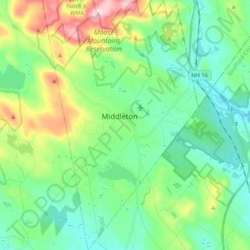
Nom : Carte topographique Middleton, altitude, relief.
Altitude moyenne : 233 m
Altitude minimum : 125 m
Altitude maximum : 524 m
According to the United States Census Bureau, the town has a total area of 18.5 square miles (47.9 km2), of which 18.1 square miles (46.8 km2) are land and 0.42 square miles (1.1 km2) are water, comprising 2.33% of the town. That water is primarily contained by Sunrise Lake, previously known as the Old Dump Reservoir, near the southern corner of the town. Sunrise Lake drains south toward the Cocheco River in Farmington, while the rest of the town drains eastward toward the Branch River, a tributary of the Salmon Falls River. Jones Brook flows through the center of town and joins the Branch River in the northern part of Milton. The entire town is part of the Piscataqua River watershed. The Moose Mountains, which separate Middleton from Brookfield, have a series of 1,600-to-1,700-foot (490 to 520 m) peaks, including the highest point in Middleton at an elevation of 1,670 feet (510 m) above sea level.
Autres cartes topographiques
Cliquez sur une carte pour visualiser sa topographie, son altitude et son relief.
Dover
United States > New Hampshire > Strafford County
Dover, Strafford County, New Hampshire, 03820, United States
Altitude moyenne : 31 m
Rochester
United States > New Hampshire > Strafford County
Rochester, Strafford County, New Hampshire, United States
Altitude moyenne : 90 m
New Durham
United States > New Hampshire > Strafford County
New Durham, Strafford County, New Hampshire, 03855, United States
Altitude moyenne : 228 m
Barrington
United States > New Hampshire > Strafford County
Barrington, Strafford County, New Hampshire, United States
Altitude moyenne : 93 m
Somersworth
United States > New Hampshire > Strafford County
Somersworth, Strafford County, New Hampshire, 03878, United States
Altitude moyenne : 56 m
Hornetown
United States > New Hampshire > Strafford County > Farmington
Hornetown, Farmington, Strafford County, New Hampshire, United States
Altitude moyenne : 225 m
Dover
United States > New Hampshire > Strafford County > Dover
Dover, Strafford County, New Hampshire, 03820, United States
Altitude moyenne : 52 m
Milton
United States > New Hampshire > Strafford County
Milton, Strafford County, New Hampshire, United States
Altitude moyenne : 183 m
Madbury
United States > New Hampshire > Strafford County
Madbury, Strafford County, New Hampshire, 03823, United States
Altitude moyenne : 34 m
Farmington
United States > New Hampshire > Strafford County
Farmington, Strafford County, New Hampshire, 03835, United States
Altitude moyenne : 168 m
Piper Mountain
United States > New Hampshire > Strafford County > Middleton
Piper Mountain, Middleton, Strafford County, New Hampshire, 03887, United States
Altitude moyenne : 216 m
Rochester
United States > New Hampshire > Strafford County > Rochester
Rochester, Strafford County, New Hampshire, 03867, United States
Altitude moyenne : 118 m
Strafford
United States > New Hampshire > Strafford County
Strafford, Strafford County, New Hampshire, United States
Altitude moyenne : 202 m
Durham
United States > New Hampshire > Strafford County
Durham, Strafford County, New Hampshire, 03824, United States
Altitude moyenne : 23 m