
Faire un don
Équipez-vous pour votre prochaine aventure :
En tant que Partenaire Amazon, ce site perçoit une commission sur les achats éligibles sans surcoût pour vous.
Carte topographique Toiyabe Range
Cliquez sur la carte pour afficher l’altitude.
Faire un don
Équipez-vous pour votre prochaine aventure :
En tant que Partenaire Amazon, ce site perçoit une commission sur les achats éligibles sans surcoût pour vous.
À propos de cette carte
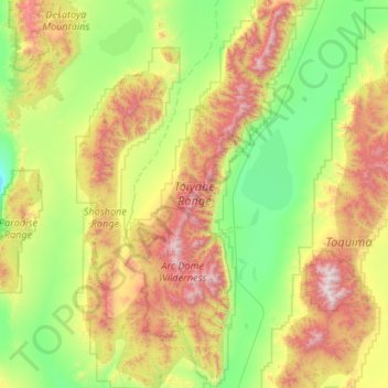
Nom : Carte topographique Toiyabe Range, altitude, relief.
Lieu : Toiyabe Range, Nye County, Nevada, 89310, United States (38.56159 -117.52007 39.38765 -117.02764)
Altitude moyenne : 2 135 m
Altitude minimum : 1 527 m
Altitude maximum : 3 599 m
Faire un don
Équipez-vous pour votre prochaine aventure :
En tant que Partenaire Amazon, ce site perçoit une commission sur les achats éligibles sans surcoût pour vous.
Autres cartes topographiques
Cliquez sur une carte pour visualiser sa topographie, son altitude et son relief.
Pahrump
United States > Nevada > Nye County
Summers in Pahrump are generally very hot and dry, with occasional pushes of monsoonal moisture beginning in early July. Being at a similar elevation to Las Vegas, daytime highs in summer average within a few degrees lower than that of Las Vegas. Record highs are similar between the two cities as well. A…
Altitude moyenne : 1 142 m
Tonopah
United States > Nevada > Nye County
Tonopah has an arid, cold desert climate with cool winters and hot summers. Due to Tonopah’s aridity and high altitude, daily temperature ranges are quite large and lows in winter are similar to many continental climates. Nights are cool, even in summer.
Altitude moyenne : 1 842 m
Amargosa Valley
United States > Nevada > Nye County
Amargosa Valley is located at 36.58001 North, 116.44487 West at an elevation of 2,640 feet (805 m) above sea level. The landscape is typical of lower to moderate elevations in the Mojave Desert, with flat expanses of sandy soil punctuated by rocky mounds and hills. Predominant indigenous vegetation is White…
Altitude moyenne : 740 m
Faire un don
Équipez-vous pour votre prochaine aventure :
En tant que Partenaire Amazon, ce site perçoit une commission sur les achats éligibles sans surcoût pour vous.
Devils Hole
United States > Nevada > Nye County
Devils Hole is a geothermal pool within a limestone cavern in the Amargosa Desert in the Amargosa Valley of Nevada, east over the Amargosa Range and Funeral Mountains from Death Valley. It is at an elevation of 730 m (2,400 ft) above sea level and the water is a constant temperature of 33 °C (91 °F). The…
Altitude moyenne : 756 m
Tonopah
United States > Nevada > Nye County
Tonopah has an arid, cold desert climate with cool winters and hot summers. Due to Tonopah’s aridity and high altitude, daily temperature ranges are quite large and lows in winter are similar to many continental climates. Nights are cool, even in summer.
Altitude moyenne : 1 842 m
Faire un don
Équipez-vous pour votre prochaine aventure :
En tant que Partenaire Amazon, ce site perçoit une commission sur les achats éligibles sans surcoût pour vous.
Pahrump
United States > Nevada > Nye County
Summers in Pahrump are generally very hot and dry, with occasional pushes of monsoonal moisture beginning in early July. Being at a similar elevation to Las Vegas, daytime highs in summer average within a few degrees lower than that of Las Vegas. Record highs are similar between the two cities as well. A…
Altitude moyenne : 1 141 m