
Carte topographique Guilin
Carte interactive
Cliquez sur la carte pour afficher l’altitude.
À propos de cette carte
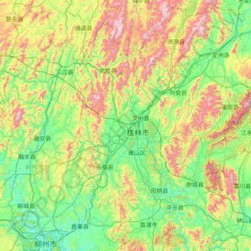
Nom : Carte topographique Guilin, altitude, relief.
Lieu : Guilin, Guangxi, China (24.26275 109.61164 26.38787 111.48759)
Altitude moyenne : 477 m
Altitude minimum : 65 m
Altitude maximum : 2 046 m
Guilin (Standard Zhuang: Gveilinz; alternatively romanized as Kweilin) is a prefecture-level city in the northeast of China's Guangxi Zhuang Autonomous Region. It is situated on the west bank of the Li River and borders Hunan to the north. Its name means "forest of sweet osmanthus", owing to the large number of fragrant sweet osmanthus trees located in the region. The city has long been renowned for its scenery of karst topography.
Autres cartes topographiques
Cliquez sur une carte pour visualiser sa topographie, son altitude et son relief.
Zhongshan
China > Guangxi > Zhongshan County
Zhongshan, Zhongshan County, Hezhou, Guangxi, China
Altitude moyenne : 246 m
Lingchuan County
Lingchuan County, Guilin, Guangxi, 541203, China
Altitude moyenne : 431 m
Long'an County
Long'an County, Nanning, Guangxi, China
Altitude moyenne : 255 m
Guanyang County
Guanyang County, Guilin, Guangxi, 541607, China
Altitude moyenne : 635 m
Pingnan County
Pingnan County, Chini, Guigang, Guangxi, China
Altitude moyenne : 36 m
Luocheng Mulao Autonomous County
Luocheng Mulao Autonomous County, Yule, Hechi, Guangxi, China
Altitude moyenne : 226 m