
Faire un don
Équipez-vous pour votre prochaine aventure :
En tant que Partenaire Amazon, ce site perçoit une commission sur les achats éligibles sans surcoût pour vous.
Carte topographique Casa de Oro
Cliquez sur la carte pour afficher l’altitude.
Faire un don
Équipez-vous pour votre prochaine aventure :
En tant que Partenaire Amazon, ce site perçoit une commission sur les achats éligibles sans surcoût pour vous.
À propos de cette carte
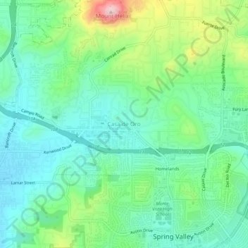
Nom : Carte topographique Casa de Oro, altitude, relief.
Altitude moyenne : 191 m
Altitude minimum : 108 m
Altitude maximum : 405 m
Faire un don
Équipez-vous pour votre prochaine aventure :
En tant que Partenaire Amazon, ce site perçoit une commission sur les achats éligibles sans surcoût pour vous.
Autres cartes topographiques
Cliquez sur une carte pour visualiser sa topographie, son altitude et son relief.
Lake San Marcos
United States > California > San Diego County > Lake San Marcos
Altitude moyenne : 201 m
Alpine
United States > California > San Diego County
Alpine sits on both sides of Interstate 8 at the eastern extent of the California coastal region and the western extent of the Peninsular Ranges, about 30 miles (48 km) east of downtown San Diego, at an elevation of about 2,000 feet (610 m).
Altitude moyenne : 581 m
Faire un don
Équipez-vous pour votre prochaine aventure :
En tant que Partenaire Amazon, ce site perçoit une commission sur les achats éligibles sans surcoût pour vous.
Encinitas
United States > California > San Diego County
Encinitas lies on rugged coastal terrace. The city is bisected by a low-lying coastal ridge that separates New and Old Encinitas. In the north of the city, the coast rises in elevation and the land is raised up in the form of many coastal bluffs. These cliffs are subject to collapsing on the narrow beach. The…
Altitude moyenne : 32 m