
Carte topographique 窝尔巴错
Carte interactive
Cliquez sur la carte pour afficher l’altitude.
À propos de cette carte
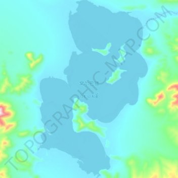
Nom : Carte topographique 窝尔巴错, altitude, relief.
Lieu : 窝尔巴错, 东汝, 日土县, 阿里地区, 西藏自治区, 中国 (34.45150 80.97800 34.60450 81.09300)
Altitude moyenne : 5 246 m
Altitude minimum : 5 190 m
Altitude maximum : 5 831 m
窝尔巴错(藏语:འོར་པ་མཚོ,威利:'or pa mtsho)位于中国西藏自治区西部阿里地区日土县多玛乡境内,地处日土县北部,面积89平方公里,湖面海拔5177米(一说5465米)。湖中有多座小岛,为世界上海拔最高的岛屿之一。北部有饮水河与东北部的邦达错连通。
Autres cartes topographiques
Cliquez sur une carte pour visualiser sa topographie, son altitude et son relief.