
Faire un don
Équipez-vous pour votre prochaine aventure :
En tant que Partenaire Amazon, ce site perçoit une commission sur les achats éligibles sans surcoût pour vous.
Carte topographique Darnestown
Cliquez sur la carte pour afficher l’altitude.
Faire un don
Équipez-vous pour votre prochaine aventure :
En tant que Partenaire Amazon, ce site perçoit une commission sur les achats éligibles sans surcoût pour vous.
Darnestown
In the 2000 census, the Census Bureau created a new Census-designated place (CDP) called Darnestown. A Darnestown CDP was also used in the 2010 census. The Darnestown CDP has 16.39 square miles (42.4 km2) of land, which is smaller than the old Darnestown MCD. The CDP uses the Muddy Branch, Turkey Foot Road, and Jones Lane for most of its eastern border instead of rivers further east. The MCD territory between Little Seneca Creek and the north side of Great Seneca Creek is also not part of the Darnestown CDP. Great Seneca Creek remains as the western border. Washington, D.C. is roughly 25 miles (40 km) away. The Travilah and North Potomac CDPs are along the Darnestown CDP's eastern border. The United States Geological Survey lists ten Darnestown-related features, including the Darnestown Census Designated Place with an elevation of 377 feet (115 m) and the Darnestown populated place (a.k.a. Darnestown village) has an elevation of 440 feet (130 m).
Faire un don
Équipez-vous pour votre prochaine aventure :
En tant que Partenaire Amazon, ce site perçoit une commission sur les achats éligibles sans surcoût pour vous.
À propos de cette carte
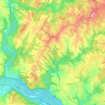
Nom : Carte topographique Darnestown, altitude, relief.
Lieu : Darnestown, Montgomery County, Maryland, United States (39.04629 -77.34358 39.13403 -77.24729)
Altitude moyenne : 97 m
Altitude minimum : 47 m
Altitude maximum : 154 m
Faire un don
Équipez-vous pour votre prochaine aventure :
En tant que Partenaire Amazon, ce site perçoit une commission sur les achats éligibles sans surcoût pour vous.
Autres cartes topographiques
Cliquez sur une carte pour visualiser sa topographie, son altitude et son relief.
Faire un don
Équipez-vous pour votre prochaine aventure :
En tant que Partenaire Amazon, ce site perçoit une commission sur les achats éligibles sans surcoût pour vous.
Faire un don
Équipez-vous pour votre prochaine aventure :
En tant que Partenaire Amazon, ce site perçoit une commission sur les achats éligibles sans surcoût pour vous.
Quail Ridge
United States > Maryland > Montgomery County > Montgomery Village
Altitude moyenne : 133 m
Great Falls
United States > Maryland > Montgomery County > Potomac
The rocks of the falls date to the late Precambrian and are about 750 million years old. The rocks are a resistant metamorphized schist, gneisses, metagraywackes, and metaconglomerates. The Falls formed the last time sea level dropped, during the Last Glacial Period about 35,000 years ago, causing the Potomac…
Altitude moyenne : 73 m
Faire un don
Équipez-vous pour votre prochaine aventure :
En tant que Partenaire Amazon, ce site perçoit une commission sur les achats éligibles sans surcoût pour vous.
Seneca
United States > Maryland > Montgomery County > Darnestown
Seneca is located close to the intersection of River Road (Maryland Route 190), Seneca Road (Maryland route 112), and Rileys Lock Road, east of Great Seneca Creek and north of the Potomac River. The C&O Canal runs along the river, and Riley's Lock is the closest canal lock. The southern portion of Seneca Creek…
Altitude moyenne : 82 m
Faire un don
Équipez-vous pour votre prochaine aventure :
En tant que Partenaire Amazon, ce site perçoit une commission sur les achats éligibles sans surcoût pour vous.
Faire un don
Équipez-vous pour votre prochaine aventure :
En tant que Partenaire Amazon, ce site perçoit une commission sur les achats éligibles sans surcoût pour vous.
Faire un don
Équipez-vous pour votre prochaine aventure :
En tant que Partenaire Amazon, ce site perçoit une commission sur les achats éligibles sans surcoût pour vous.
Brookeville Heights
United States > Maryland > Montgomery County > Brookeville Heights
Altitude moyenne : 139 m
Faire un don
Équipez-vous pour votre prochaine aventure :
En tant que Partenaire Amazon, ce site perçoit une commission sur les achats éligibles sans surcoût pour vous.
Rockcrest
United States > Maryland > Montgomery County > Rockville > Rockcrest
Altitude moyenne : 114 m
Garrett Park Estates
United States > Maryland > Montgomery County > Garrett Park Estates
Altitude moyenne : 97 m
Faire un don
Équipez-vous pour votre prochaine aventure :
En tant que Partenaire Amazon, ce site perçoit une commission sur les achats éligibles sans surcoût pour vous.