
Faire un don
Équipez-vous pour votre prochaine aventure :
En tant que Partenaire Amazon, ce site perçoit une commission sur les achats éligibles sans surcoût pour vous.
Carte topographique Bahraich
Cliquez sur la carte pour afficher l’altitude.
Faire un don
Équipez-vous pour votre prochaine aventure :
En tant que Partenaire Amazon, ce site perçoit une commission sur les achats éligibles sans surcoût pour vous.
Bahraich
It has an average elevation of 126 metres (413 feet). Bahraich has a warm humid subtropical climate with hot summers from April to July. The rainy season is from July to mid-September when Bahraich gets an average rainfall from the south-west monsoon winds, and occasionally frontal rainfall will occur in January. In winter the maximum temperature is around 25 °C (77 °F) and the minimum is in the −1 to 7 °C (30 to 45 °F) range. Fog is quite common from late December to late January. Summers are extremely hot with temperatures rising to the 40 to 47 °C (104 to 117 °F) range, the average highs being in the high of 30s (degree Celsius). Average annual rainfall is 1,900 centimetres (750 inches) (approx).
Faire un don
Équipez-vous pour votre prochaine aventure :
En tant que Partenaire Amazon, ce site perçoit une commission sur les achats éligibles sans surcoût pour vous.
À propos de cette carte
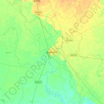
Nom : Carte topographique Bahraich, altitude, relief.
Lieu : Bahraich, Bahraich District, Uttar Pradesh, 271801, India (27.41520 81.43540 27.73520 81.75540)
Altitude moyenne : 120 m
Altitude minimum : 109 m
Altitude maximum : 134 m
Faire un don
Équipez-vous pour votre prochaine aventure :
En tant que Partenaire Amazon, ce site perçoit une commission sur les achats éligibles sans surcoût pour vous.