
Carte topographique Cooum
Cliquez sur la carte pour afficher l’altitude.
À propos de cette carte
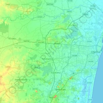
Nom : Carte topographique Cooum, altitude, relief.
Altitude moyenne : 27 m
Altitude minimum : -1 m
Altitude maximum : 158 m
Autres cartes topographiques
Cliquez sur une carte pour visualiser sa topographie, son altitude et son relief.
Avadi
India > Tamil Nadu > Poonamallee
Avadi is located at 13°07′N 80°06′E / 13.12°N 80.1°E / 13.12; 80.1. It covers an area of 65 square kilometres (25 sq mi) and has an average elevation of 17 metres (56 ft).
Altitude moyenne : 23 m
Avadi
India > Tamil Nadu > Poonamallee
Avadi is located at 13°07′N 80°06′E / 13.12°N 80.1°E / 13.12; 80.1. It covers an area of 65 square kilometres (25 sq mi) and has an average elevation of 17 metres (56 ft).
Altitude moyenne : 23 m
Avadi
India > Tamil Nadu > Poonamallee
Avadi is located at 13°07′N 80°06′E / 13.12°N 80.1°E / 13.12; 80.1. It covers an area of 65 square kilometres (25 sq mi) and has an average elevation of 17 metres (56 ft). Avadi is the one of the largest locality in Chennai, stretching from Poonamalle High Road to MTH Road.
Altitude moyenne : 23 m
Avadi
India > Tamil Nadu > Poonamallee
Avadi is located at 13°07′N 80°06′E / 13.12°N 80.1°E / 13.12; 80.1. It covers an area of 65 square kilometres (25 sq mi) and has an average elevation of 17 metres (56 ft). Avadi is one of the largest localities in Chennai, stretching from Poonamalle High Road to MTH Road.
Altitude moyenne : 23 m