
Carte topographique Gänsruh
Carte interactive
Cliquez sur la carte pour afficher l’altitude.
À propos de cette carte
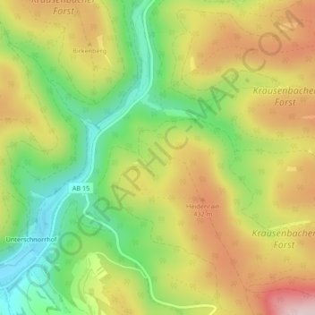
Nom : Carte topographique Gänsruh, altitude, relief.
Altitude moyenne : 363 m
Altitude minimum : 227 m
Altitude maximum : 510 m
Autres cartes topographiques
Cliquez sur une carte pour visualiser sa topographie, son altitude et son relief.
Oberwintersbach (Geishöhe)
Deutschland > Bayern > Landkreis Aschaffenburg > Dammbach
Oberwintersbach (Geishöhe), Wintersbach, Dammbach, Mespelbrunn (VGem), Landkreis Aschaffenburg, Bayern, 63874, Deutschland
Altitude moyenne : 398 m