
Faire un don
Équipez-vous pour votre prochaine aventure :
En tant que Partenaire Amazon, ce site perçoit une commission sur les achats éligibles sans surcoût pour vous.
Carte topographique Steiner Ranch
Cliquez sur la carte pour afficher l’altitude.
Faire un don
Équipez-vous pour votre prochaine aventure :
En tant que Partenaire Amazon, ce site perçoit une commission sur les achats éligibles sans surcoût pour vous.
À propos de cette carte
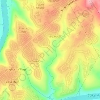
Nom : Carte topographique Steiner Ranch, altitude, relief.
Lieu : Steiner Ranch, Travis County, Texas, 78732, United States (30.34569 -97.90942 30.36569 -97.88942)
Altitude moyenne : 221 m
Altitude minimum : 141 m
Altitude maximum : 285 m
Faire un don
Équipez-vous pour votre prochaine aventure :
En tant que Partenaire Amazon, ce site perçoit une commission sur les achats éligibles sans surcoût pour vous.
Autres cartes topographiques
Cliquez sur une carte pour visualiser sa topographie, son altitude et son relief.
Austin
United States > Texas > Travis County
Austin features a diverse and varied topography shaped by its position along the Balcones Fault. The city’s elevation ranges from about 425 feet to approximately 1,000 feet above sea level, creating a landscape characterized by rolling hills and elevated areas particularly in the western regions. To the…
Altitude moyenne : 216 m
Faire un don
Équipez-vous pour votre prochaine aventure :
En tant que Partenaire Amazon, ce site perçoit une commission sur les achats éligibles sans surcoût pour vous.
Lago Vista
United States > Texas > Travis County
Lago Vista is situated on the northern shore of Lake Travis within the Texas Hill Country. The area's terrain is notably rugged, with steep limestone hills and canyons. Elevations range from about 774 feet near the lake to 1,220 feet near Rusty Allen Airport, making it one of the highest points in Travis…
Altitude moyenne : 251 m
Austin
United States > Texas > Travis County
The elevation of Austin varies from 425 feet (130 m) to approximately 1,000 feet (305 m) above sea level. Due to the fact it straddles the Balcones Fault, much of the eastern part of the city is flat, with heavy clay and loam soils, whereas the western part and western suburbs consist of rolling hills on the…
Altitude moyenne : 216 m
Faire un don
Équipez-vous pour votre prochaine aventure :
En tant que Partenaire Amazon, ce site perçoit une commission sur les achats éligibles sans surcoût pour vous.
Bee Cave
United States > Texas > Travis County
According to the United States Census Bureau in 2010, the city has a total area of 2.6 square miles (6.7 km2), all of it land. Prior to the 2010 census, Bee Cave went from being a village to being a city, increasing its area to 6.8 square miles (18 km2), all land. It borders Lakeway to the northwest. The…
Altitude moyenne : 270 m
Circle C Ranch Metropolitan Park on Slaughter Creek
United States > Texas > Travis County > Austin
Altitude moyenne : 259 m
Faire un don
Équipez-vous pour votre prochaine aventure :
En tant que Partenaire Amazon, ce site perçoit une commission sur les achats éligibles sans surcoût pour vous.
Roy G. Guerrero Colorado River Metro Park
United States > Texas > Travis County > Austin
Altitude moyenne : 141 m
Shoal Beach at Town Lake Metropolitan Park
United States > Texas > Travis County > Austin
Altitude moyenne : 152 m
Faire un don
Équipez-vous pour votre prochaine aventure :
En tant que Partenaire Amazon, ce site perçoit une commission sur les achats éligibles sans surcoût pour vous.
Walter E. Long Metropolitan Park
United States > Texas > Travis County > Austin
Altitude moyenne : 174 m
Faire un don
Équipez-vous pour votre prochaine aventure :
En tant que Partenaire Amazon, ce site perçoit une commission sur les achats éligibles sans surcoût pour vous.
Faire un don
Équipez-vous pour votre prochaine aventure :
En tant que Partenaire Amazon, ce site perçoit une commission sur les achats éligibles sans surcoût pour vous.
Austin
United States > Texas > Travis County
The elevation of Austin varies from 425 feet (130 m) to approximately 1,000 feet (305 m) above sea level. Due to the fact it straddles the Balcones Fault, much of the eastern part of the city is flat, with heavy clay and loam soils, whereas the western part and western suburbs consist of rolling hills on the…
Altitude moyenne : 216 m
Faire un don
Équipez-vous pour votre prochaine aventure :
En tant que Partenaire Amazon, ce site perçoit une commission sur les achats éligibles sans surcoût pour vous.
Austin
United States > Texas > Travis County
The elevation of Austin varies from 425 feet (130 m) to approximately 1,000 feet (305 m) above sea level. Due to the fact it straddles the Balcones Fault, much of the eastern part of the city is flat, with heavy clay and loam soils, whereas the western part and western suburbs consist of rolling hills on the…
Altitude moyenne : 216 m
Faire un don
Équipez-vous pour votre prochaine aventure :
En tant que Partenaire Amazon, ce site perçoit une commission sur les achats éligibles sans surcoût pour vous.
Bee Cave
United States > Texas > Travis County
According to the United States Census Bureau in 2010, the city has a total area of 2.6 square miles (6.7 km2), all of it land. Prior to the 2010 census, Bee Cave went from being a village to being a city, increasing its area to 6.8 square miles (18 km2), all land. It borders Lakeway to the northwest. The…
Altitude moyenne : 270 m
Lago Vista
United States > Texas > Travis County
According to the United States Census Bureau, the city has a total area of 15.52 sq mi (40.2 km2) of which 14.6 sq mi (38 km2) is land and 0.6 sq mi (1.6 km2) (3.95%) is water. The peninsular city sits adjacent to, and partially within, the Balcones Canyonlands. Lago Vista has rugged terrain with elevations…
Altitude moyenne : 251 m
Faire un don
Équipez-vous pour votre prochaine aventure :
En tant que Partenaire Amazon, ce site perçoit une commission sur les achats éligibles sans surcoût pour vous.