
Faire un don
Équipez-vous pour votre prochaine aventure :
En tant que Partenaire Amazon, ce site perçoit une commission sur les achats éligibles sans surcoût pour vous.
Carte topographique Tecopa
Cliquez sur la carte pour afficher l’altitude.
Faire un don
Équipez-vous pour votre prochaine aventure :
En tant que Partenaire Amazon, ce site perçoit une commission sur les achats éligibles sans surcoût pour vous.
Tecopa
Tecopa (formerly Brownsville[4]) is a census-designated place (CDP) in the Mojave Desert, in Inyo County, California, United States. Tecopa is located 9 miles (14 km) south-southeast of Shoshone,[4] at an elevation of 1,339 feet (408 m).[3] The population was 150 at the 2010 census, up from 99 at the 2000 census.
Faire un don
Équipez-vous pour votre prochaine aventure :
En tant que Partenaire Amazon, ce site perçoit une commission sur les achats éligibles sans surcoût pour vous.
À propos de cette carte
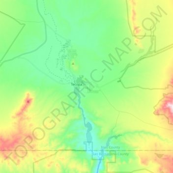
Nom : Carte topographique Tecopa, altitude, relief.
Lieu : Tecopa, Inyo County, California, United States (35.79330 -116.28677 35.89955 -116.10947)
Altitude moyenne : 508 m
Altitude minimum : 308 m
Altitude maximum : 926 m
Faire un don
Équipez-vous pour votre prochaine aventure :
En tant que Partenaire Amazon, ce site perçoit une commission sur les achats éligibles sans surcoût pour vous.