
Faire un don
Équipez-vous pour votre prochaine aventure :
En tant que Partenaire Amazon, ce site perçoit une commission sur les achats éligibles sans surcoût pour vous.
Carte topographique Xiangkhouang
Cliquez sur la carte pour afficher l’altitude.
Faire un don
Équipez-vous pour votre prochaine aventure :
En tant que Partenaire Amazon, ce site perçoit une commission sur les achats éligibles sans surcoût pour vous.
Xiangkhouang
Xiangkhouang province covers an area of 15,880 square kilometres (6,130 sq mi) and is mountainous. Apart from floodplains, the largest area of level land in the country is on the province's Xiangkhoang Plateau. The plateau is characterized by rolling hills and grassland whose elevation averages 1,300 metres (4,300 ft). The country's highest peak, Phou Bia (2,820 metres (9,250 ft)), rises at the south side of the plateau. Nam Et-Phou Louey is a National Biodiversity Conservation Area (NBCA) in the province, covering an area of 5,959 km2, and overlaps into Houaphanh and Luang Prabang provinces.
Faire un don
Équipez-vous pour votre prochaine aventure :
En tant que Partenaire Amazon, ce site perçoit une commission sur les achats éligibles sans surcoût pour vous.
À propos de cette carte
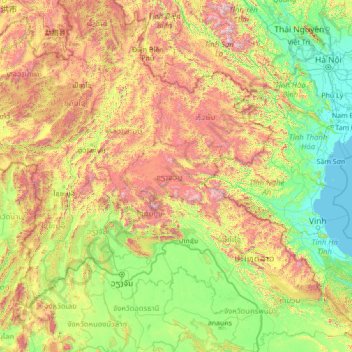
Nom : Carte topographique Xiangkhouang, altitude, relief.
Lieu : Xiangkhouang, Laos (16.81305 100.86801 22.01305 106.06801)
Altitude moyenne : 565 m
Altitude minimum : -1 m
Altitude maximum : 2 730 m
Faire un don
Équipez-vous pour votre prochaine aventure :
En tant que Partenaire Amazon, ce site perçoit une commission sur les achats éligibles sans surcoût pour vous.
Autres cartes topographiques
Cliquez sur une carte pour visualiser sa topographie, son altitude et son relief.
Mekong
The elevation of the Tibetan Plateau during the Tertiary period was an important factor in the genesis of the south-west monsoon, which is the dominant climatic control influencing the hydrology of the Mekong Basin. Understanding the nature and timing of the elevation of Tibet (and the Central Highlands of…
Altitude moyenne : 795 m
Phongsaly
Phongsaly province covers an area of 16,270 square kilometres (6,280 sq mi), of which 77% has forest cover. It borders China to the north and west, Vietnam to the east, Luang Prabang province to the south, and Oudomxai province to the southwest. The highest mountain in the province is Phou Doychy with an…
Altitude moyenne : 933 m
Faire un don
Équipez-vous pour votre prochaine aventure :
En tant que Partenaire Amazon, ce site perçoit une commission sur les achats éligibles sans surcoût pour vous.
Attapeu
Dong Ampham National Biodiversity Conservation Area (NBCA) lies partly in Attapeu province (for the northeastern part) and Sekong province (for the southeastern part), on the border with Vietnam. The NBCA is forested and covers about 200,000 hectares. Established in 1993, it is one of the 23 National…
Altitude moyenne : 599 m
Faire un don
Équipez-vous pour votre prochaine aventure :
En tant que Partenaire Amazon, ce site perçoit une commission sur les achats éligibles sans surcoût pour vous.
Sing District
Muang Sing is in northwestern Laos in the northern part of Luang Namtha Province. The town lies about 60 kilometres northwest of the town of Luang Namtha, 77 kilometres northeast by road from Xieng Kok on the Burmese border and about 360 kilometres northwest of Vientiane. The district, which has jurisdiction…
Altitude moyenne : 933 m
Salavan Province
Its origin is volcanic with mountains and valleys. The central part of the province is located on the Bolaven Plateau, which is an agricultural area with Arabica coffee as the dominant cash crop and other horticultural products which are exported. The western part of Salavan province is delimited by the Mekong…
Altitude moyenne : 469 m
Bokeo Province
The Bokeo Nature Reserve was created as protection for the black crested gibbon (also known as "black-cheeked gibbon"), discovered in 1997, previously thought to be extinct. Elephants and wild water buffalo migrate through the reserve; bears and tigers are present. The protected area, is characterized by a…
Altitude moyenne : 609 m
Faire un don
Équipez-vous pour votre prochaine aventure :
En tant que Partenaire Amazon, ce site perçoit une commission sur les achats éligibles sans surcoût pour vous.
Houaphanh
The Nam Neun IBA area of Nam Et is adjacent to the NBCA. Nam Neun is 85,450 ha in size, and is at an elevation of 800–1,500 metres (2,600–4,900 ft). The habitat is characterized as mixed deciduous forest, and dry evergreen forest, with stands of bamboo, and occasional conifers; cleared areas have been…
Altitude moyenne : 963 m
Faire un don
Équipez-vous pour votre prochaine aventure :
En tant que Partenaire Amazon, ce site perçoit une commission sur les achats éligibles sans surcoût pour vous.
Sekong Province
The Dakchung Plateau is an Important Bird Area (IBA). It is 5,140 ha in size, and at an elevation of 800–1,400 metres (2,600–4,600 ft). The habitat is characterized as pine woodland, grassland, degraded semi-evergreen forest, dry evergreen forest, marshy land, and tall grasses areas. Of the avifauna, the…
Altitude moyenne : 771 m
Mekong
The elevation of the Tibetan Plateau during the Tertiary period was an important factor in the genesis of the south-west monsoon, which is the dominant climatic control influencing the hydrology of the Mekong Basin. Understanding the nature and timing of the elevation of Tibet (and the Central Highlands of…
Altitude moyenne : 795 m
Faire un don
Équipez-vous pour votre prochaine aventure :
En tant que Partenaire Amazon, ce site perçoit une commission sur les achats éligibles sans surcoût pour vous.
Vientiane Province
Phou Khao Khouay National Biodiversity Conservation Area is a protected area 40 kilometres (25 mi) northeast of Vientiane. It was established on 29 October 1993 covering an area of 2,000 km2 extending into Khet Phiset Xaisomboon (special zone), Vientiane prefecture, and Vientiane province. Its mountainous…
Altitude moyenne : 526 m
Mekong
The elevation of the Tibetan Plateau during the Tertiary period was an important factor in the genesis of the south-west monsoon, which is the dominant climatic control influencing the hydrology of the Mekong Basin. Understanding the nature and timing of the elevation of Tibet (and the Central Highlands of…
Altitude moyenne : 795 m
Faire un don
Équipez-vous pour votre prochaine aventure :
En tant que Partenaire Amazon, ce site perçoit une commission sur les achats éligibles sans surcoût pour vous.
Xiangkhouang Province
Xiangkhouang province covers an area of 15,880 square kilometres (6,130 sq mi) and is mountainous. Apart from floodplains, the largest area of level land in the country is on the province's Xiangkhoang Plateau. The plateau is characterized by rolling hills and grassland whose elevation averages 1,300 metres…
Altitude moyenne : 1 001 m
Faire un don
Équipez-vous pour votre prochaine aventure :
En tant que Partenaire Amazon, ce site perçoit une commission sur les achats éligibles sans surcoût pour vous.
Bokeo Province
The Bokeo Nature Reserve was created as protection for the black crested gibbon (also known as "black-cheeked gibbon"), discovered in 1997, previously thought to be extinct. Elephants and wild water buffalo migrate through the reserve; bears and tigers are also present. The protected area, is characterized by…
Altitude moyenne : 609 m
Faire un don
Équipez-vous pour votre prochaine aventure :
En tant que Partenaire Amazon, ce site perçoit une commission sur les achats éligibles sans surcoût pour vous.
Nongtha Marsh
Laos > Vientiane Prefecture > Chanthabuly District > Vientiane Capital > B. Nongthanua
Altitude moyenne : 175 m
Xay District
Oudomxay Province has a moderate monsoon climate. Due to its relatively high elevation, there are more variations in temperature during the year and a colder dry season in northern Laos than in the rest of the country.
Altitude moyenne : 855 m
Faire un don
Équipez-vous pour votre prochaine aventure :
En tant que Partenaire Amazon, ce site perçoit une commission sur les achats éligibles sans surcoût pour vous.
Faire un don
Équipez-vous pour votre prochaine aventure :
En tant que Partenaire Amazon, ce site perçoit une commission sur les achats éligibles sans surcoût pour vous.
Luang Prabang
The 60,070 hectare Phou Louey Massif Important Bird Area (IBA) is in the Nam Et-Phou Louey National Biodiversity Conservation Area (NBCA). The IBA is in the provinces of Luang Prabang and Houaphanh. It sits at an elevation of 700–1,800 metres (2,300–5,900 ft). The habitat contains mixed deciduous forest,…
Altitude moyenne : 910 m
Faire un don
Équipez-vous pour votre prochaine aventure :
En tant que Partenaire Amazon, ce site perçoit une commission sur les achats éligibles sans surcoût pour vous.
Champasak Province
The Mekong Channel from Phou Xiang Thong to Siphandon Important Bird Area (IBA) is 34,200 ha (85,000 acres) in size. A portion of the IBA (10,000 hectares) overlaps with the 120,000 ha (300,000 acres) Phou Xieng Thong National Protected Area. The IBA encompasses two provinces, Champasak and Salavan. The IBA is…
Altitude moyenne : 262 m
Faire un don
Équipez-vous pour votre prochaine aventure :
En tant que Partenaire Amazon, ce site perçoit une commission sur les achats éligibles sans surcoût pour vous.
Mekong
The elevation of the Tibetan Plateau during the Tertiary period was an important factor in the genesis of the south-west monsoon, which is the dominant climatic control influencing the hydrology of the Mekong Basin. Understanding the nature and timing of the elevation of Tibet (and the Central Highlands of…
Altitude moyenne : 795 m
Bolikhamsai
Bolikhamsai province has a rugged terrain, with large boulders and streams. Its elevation ranges from 140–1,588 metres (459–5,210 ft). The principal river is the Nam Kading, meaning 'water like a bell', a tributary of the Mekong; its catchment covers about 92% of the provincial area. The other main rivers…
Altitude moyenne : 528 m
Faire un don
Équipez-vous pour votre prochaine aventure :
En tant que Partenaire Amazon, ce site perçoit une commission sur les achats éligibles sans surcoût pour vous.
Attapeu
Dong Ampham National Biodiversity Conservation Area (NBCA) lies partly in Attapeu province (for the northeastern part) and Sekong province (for the southeastern part), on the border with Vietnam. The NBCA is forested and covers about 200,000 hectares. Established in 1993, it is one of the 23 National…
Altitude moyenne : 599 m
Sekong Province
The Dakchung Plateau is an Important Bird Area (IBA). It is 5,140 ha in size, and at an elevation of 800–1,400 metres (2,600–4,600 ft). The habitat is characterized as pine woodland, grassland, degraded semi-evergreen forest, dry evergreen forest, marshy land, and tall grasses areas. Of the avifauna, the…
Altitude moyenne : 771 m
Faire un don
Équipez-vous pour votre prochaine aventure :
En tant que Partenaire Amazon, ce site perçoit une commission sur les achats éligibles sans surcoût pour vous.
Luang Prabang
The 60,070 hectare Phou Louey Massif Important Bird Area (IBA) is in the Nam Et-Phou Louey National Biodiversity Conservation Area (NBCA). The IBA is in the provinces of Luang Prabang and Houaphanh. It sits at an elevation of 700–1,800 metres (2,300–5,900 ft). The habitat contains mixed deciduous forest,…
Altitude moyenne : 910 m
Faire un don
Équipez-vous pour votre prochaine aventure :
En tant que Partenaire Amazon, ce site perçoit une commission sur les achats éligibles sans surcoût pour vous.