
Faire un don
Équipez-vous pour votre prochaine aventure :
En tant que Partenaire Amazon, ce site perçoit une commission sur les achats éligibles sans surcoût pour vous.
Carte topographique Mount Mitchell State Park
Cliquez sur la carte pour afficher l’altitude.
Faire un don
Équipez-vous pour votre prochaine aventure :
En tant que Partenaire Amazon, ce site perçoit une commission sur les achats éligibles sans surcoût pour vous.
Mount Mitchell State Park
In addition to Mount Mitchell itself, the park encompasses several other peaks which top out at over 6,000 feet (1,800 m) in elevation, including Mount Hallback, Mount Craig (just 52 feet (16 m) shy of Mount Mitchell in elevation and the second highest peak east of the Mississippi River), Big Tom and Balsam Cone. Trails lead to all these summits save Mount Hallback, and their exploration takes visitors away from the crowds on Mount Mitchell but to places similarly spectacular. About 8 miles (13 km) of trails exist within the park in all.
Faire un don
Équipez-vous pour votre prochaine aventure :
En tant que Partenaire Amazon, ce site perçoit une commission sur les achats éligibles sans surcoût pour vous.
À propos de cette carte
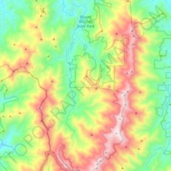
Nom : Carte topographique Mount Mitchell State Park, altitude, relief.
Altitude moyenne : 1 271 m
Altitude minimum : 777 m
Altitude maximum : 2 017 m
Faire un don
Équipez-vous pour votre prochaine aventure :
En tant que Partenaire Amazon, ce site perçoit une commission sur les achats éligibles sans surcoût pour vous.