
Carte topographique Barra
Cliquez sur la carte pour afficher l’altitude.
Barra
The highest elevation on the island is Heaval, near the top of which is a prominent white marble statue of the Madonna and Child, called "Our Lady of the Sea", which was erected during the Marian year of 1954. The predominant faith on the island is Catholicism and the Catholic church dedicated to Our Lady of the Sea is apparent to those arriving at Castlebay.
À propos de cette carte
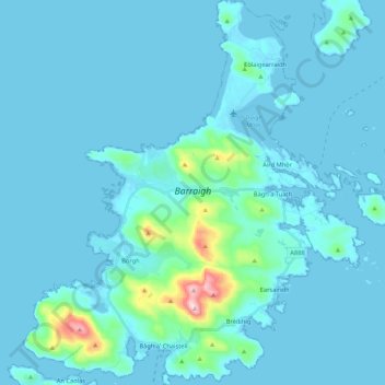
Nom : Carte topographique Barra, altitude, relief.
Lieu : Barra, Borve, Western Isles, Scotland, United Kingdom (56.94325 -7.56278 57.05895 -7.36846)
Altitude moyenne : 27 m
Altitude minimum : -1 m
Altitude maximum : 373 m
Autres cartes topographiques
Cliquez sur une carte pour visualiser sa topographie, son altitude et son relief.