
Faire un don
Équipez-vous pour votre prochaine aventure :
En tant que Partenaire Amazon, ce site perçoit une commission sur les achats éligibles sans surcoût pour vous.
Carte topographique Perry Green
Cliquez sur la carte pour afficher l’altitude.
Faire un don
Équipez-vous pour votre prochaine aventure :
En tant que Partenaire Amazon, ce site perçoit une commission sur les achats éligibles sans surcoût pour vous.
À propos de cette carte
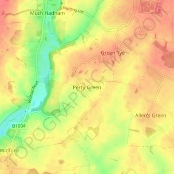
Nom : Carte topographique Perry Green, altitude, relief.
Altitude moyenne : 78 m
Altitude minimum : 44 m
Altitude maximum : 98 m
Faire un don
Équipez-vous pour votre prochaine aventure :
En tant que Partenaire Amazon, ce site perçoit une commission sur les achats éligibles sans surcoût pour vous.
Autres cartes topographiques
Cliquez sur une carte pour visualiser sa topographie, son altitude et son relief.
Astonbury Wood
United Kingdom > England > Hertfordshire > East Hertfordshire > Aston
Altitude moyenne : 83 m
Sawbridgeworth
United Kingdom > England > Hertfordshire > East Hertfordshire > Sawbridgeworth
Altitude moyenne : 67 m
Faire un don
Équipez-vous pour votre prochaine aventure :
En tant que Partenaire Amazon, ce site perçoit une commission sur les achats éligibles sans surcoût pour vous.
Bishop's Stortford
United Kingdom > England > Hertfordshire > East Hertfordshire
Stortford, along with the rest of Britain, has a temperate maritime climate, with cool summers and mild winters. The nearest weather station for which averages and extremes are available is Stansted Airport, about 2+1⁄2 miles (4 kilometres) due east of Stortford's town centre. Located at an elevation of over…
Altitude moyenne : 83 m
Faire un don
Équipez-vous pour votre prochaine aventure :
En tant que Partenaire Amazon, ce site perçoit une commission sur les achats éligibles sans surcoût pour vous.
King's Meads
United Kingdom > England > Hertfordshire > East Hertfordshire > Ware
Altitude moyenne : 53 m
Faire un don
Équipez-vous pour votre prochaine aventure :
En tant que Partenaire Amazon, ce site perçoit une commission sur les achats éligibles sans surcoût pour vous.
Furneux Pelham
United Kingdom > England > Hertfordshire > East Hertfordshire > Furneux Pelham
Altitude moyenne : 113 m
Thundridge
United Kingdom > England > Hertfordshire > East Hertfordshire > High Cross
Altitude moyenne : 78 m
Stocking Pelham
United Kingdom > England > Hertfordshire > East Hertfordshire > Stocking Pelham
Altitude moyenne : 114 m
Faire un don
Équipez-vous pour votre prochaine aventure :
En tant que Partenaire Amazon, ce site perçoit une commission sur les achats éligibles sans surcoût pour vous.
Little Berkhamsted
United Kingdom > England > Hertfordshire > East Hertfordshire
Altitude moyenne : 88 m
Datchworth
United Kingdom > England > Hertfordshire > East Hertfordshire > Datchworth
Altitude moyenne : 102 m
Thorley
United Kingdom > England > Hertfordshire > East Hertfordshire > Thorley
Altitude moyenne : 82 m
Faire un don
Équipez-vous pour votre prochaine aventure :
En tant que Partenaire Amazon, ce site perçoit une commission sur les achats éligibles sans surcoût pour vous.
Buntingford
United Kingdom > England > Hertfordshire > East Hertfordshire > Buntingford
Altitude moyenne : 110 m
Widford
United Kingdom > England > Hertfordshire > East Hertfordshire > Widford
Altitude moyenne : 73 m
Faire un don
Équipez-vous pour votre prochaine aventure :
En tant que Partenaire Amazon, ce site perçoit une commission sur les achats éligibles sans surcoût pour vous.
Hertford Heath Nature Reserve
United Kingdom > England > Hertfordshire > East Hertfordshire > Hertford Heath
Altitude moyenne : 79 m
Stocking Pelham
United Kingdom > England > Hertfordshire > East Hertfordshire
Altitude moyenne : 114 m
Faire un don
Équipez-vous pour votre prochaine aventure :
En tant que Partenaire Amazon, ce site perçoit une commission sur les achats éligibles sans surcoût pour vous.
Hertford Lock No 1
United Kingdom > England > Hertfordshire > East Hertfordshire > Hertford
Altitude moyenne : 53 m
Braughing
United Kingdom > England > Hertfordshire > East Hertfordshire > Braughing
Altitude moyenne : 104 m
Faire un don
Équipez-vous pour votre prochaine aventure :
En tant que Partenaire Amazon, ce site perçoit une commission sur les achats éligibles sans surcoût pour vous.
Sawbridgeworth
United Kingdom > England > Hertfordshire > East Hertfordshire > Sawbridgeworth
Altitude moyenne : 67 m
Buntingford
United Kingdom > England > Hertfordshire > East Hertfordshire > Buntingford
Altitude moyenne : 110 m