
Faire un don
Équipez-vous pour votre prochaine aventure :
En tant que Partenaire Amazon, ce site perçoit une commission sur les achats éligibles sans surcoût pour vous.
Carte topographique Hucknall
Cliquez sur la carte pour afficher l’altitude.
Faire un don
Équipez-vous pour votre prochaine aventure :
En tant que Partenaire Amazon, ce site perçoit une commission sur les achats éligibles sans surcoût pour vous.
Hucknall
Hucknall Airfield, built in 1916, became RAF Hucknall. From 1927, Rolls-Royce began using the airfield for flight tests. During World War II, the aerodrome at Hucknall launched the first flight of a P-51 Mustang fitted with a Rolls-Royce Merlin Engine. The Merlin, replacing the earlier Allison V-1710 engine, allowed the Mustang air frame to reach its full potential and achieve spectacular high-altitude performance.
Faire un don
Équipez-vous pour votre prochaine aventure :
En tant que Partenaire Amazon, ce site perçoit une commission sur les achats éligibles sans surcoût pour vous.
À propos de cette carte
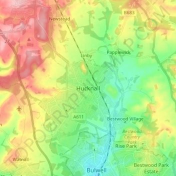
Nom : Carte topographique Hucknall, altitude, relief.
Altitude moyenne : 104 m
Altitude minimum : 44 m
Altitude maximum : 186 m
Faire un don
Équipez-vous pour votre prochaine aventure :
En tant que Partenaire Amazon, ce site perçoit une commission sur les achats éligibles sans surcoût pour vous.
Autres cartes topographiques
Cliquez sur une carte pour visualiser sa topographie, son altitude et son relief.
Sutton Lawn
United Kingdom > England > Nottinghamshire > Ashfield > Sutton-in-Ashfield
Altitude moyenne : 155 m
Sutton in Ashfield
United Kingdom > England > Nottinghamshire > Ashfield > Stanton Hill
Altitude moyenne : 154 m
Faire un don
Équipez-vous pour votre prochaine aventure :
En tant que Partenaire Amazon, ce site perçoit une commission sur les achats éligibles sans surcoût pour vous.