
Faire un don
Équipez-vous pour votre prochaine aventure :
En tant que Partenaire Amazon, ce site perçoit une commission sur les achats éligibles sans surcoût pour vous.
Carte topographique Double Horn
Cliquez sur la carte pour afficher l’altitude.
Faire un don
Équipez-vous pour votre prochaine aventure :
En tant que Partenaire Amazon, ce site perçoit une commission sur les achats éligibles sans surcoût pour vous.
Double Horn
The original settlement of Double Horn was established near the headwaters of Double Horn Creek in 1855, with the creek and town named for an incident where a pioneer found the remains of two bucks with interlocked antlers. It had a post office from 1857 to 1911, a school (the Double Horn School), a cotton gin, and two churches. In 1884, the population was 50; by 1896, this population had halved, and by 1936, only the school remained marked on state road maps. Double Horn had completely disappeared from maps as a separate community by the second half of the 20th century. This location is close to a lightly populated ranching area marked on modern topographic maps as Shovel Mountain.
Faire un don
Équipez-vous pour votre prochaine aventure :
En tant que Partenaire Amazon, ce site perçoit une commission sur les achats éligibles sans surcoût pour vous.
À propos de cette carte
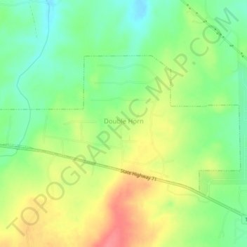
Nom : Carte topographique Double Horn, altitude, relief.
Lieu : Double Horn, Burnet County, Texas, United States (30.48668 -98.24417 30.50651 -98.20258)
Altitude moyenne : 287 m
Altitude minimum : 253 m
Altitude maximum : 329 m
Faire un don
Équipez-vous pour votre prochaine aventure :
En tant que Partenaire Amazon, ce site perçoit une commission sur les achats éligibles sans surcoût pour vous.
Autres cartes topographiques
Cliquez sur une carte pour visualiser sa topographie, son altitude et son relief.
Faire un don
Équipez-vous pour votre prochaine aventure :
En tant que Partenaire Amazon, ce site perçoit une commission sur les achats éligibles sans surcoût pour vous.
Marble Falls
United States > Texas > Burnet County > Marble Falls > Marble Falls
Altitude moyenne : 261 m