
Faire un don
Équipez-vous pour votre prochaine aventure :
En tant que Partenaire Amazon, ce site perçoit une commission sur les achats éligibles sans surcoût pour vous.
Carte topographique El Capitan
Cliquez sur la carte pour afficher l’altitude.
Faire un don
Équipez-vous pour votre prochaine aventure :
En tant que Partenaire Amazon, ce site perçoit une commission sur les achats éligibles sans surcoût pour vous.
À propos de cette carte
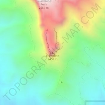
Nom : Carte topographique El Capitan, altitude, relief.
Lieu : El Capitan, Culberson County, Texas, 79847, United States (31.87729 -104.85805 31.87739 -104.85795)
Altitude moyenne : 1 916 m
Altitude minimum : 1 564 m
Altitude maximum : 2 613 m
Faire un don
Équipez-vous pour votre prochaine aventure :
En tant que Partenaire Amazon, ce site perçoit une commission sur les achats éligibles sans surcoût pour vous.
Autres cartes topographiques
Cliquez sur une carte pour visualiser sa topographie, son altitude et son relief.
Van Horn
United States > Texas > Culberson County
According to the United States Census Bureau, the town has a total area of 2.8 square miles (7.3 km2), all land. Threemile Peak, elevation 4,868 feet (1,484 m), rises to the northwest overlooking the town.
Altitude moyenne : 1 242 m
Guadalupe Mountains National Park
United States > Texas > Culberson County
The Guadalupe Mountains reach their highest point at Guadalupe Peak, the highest point in Texas, with an elevation of 8,751 feet (2,667 m). The range lies southeast of the Sacramento Mountains and east of the Brokeoff Mountains. The mountain range extends north-northwest and northeast from Guadalupe Peak in…
Altitude moyenne : 1 484 m
Van Horn
United States > Texas > Culberson County
According to the United States Census Bureau, the town has a total area of 2.8 square miles (7.3 km2), all land. Threemile Peak, elevation 4,868 feet (1,484 m), rises to the northwest overlooking the town.
Altitude moyenne : 1 242 m
Faire un don
Équipez-vous pour votre prochaine aventure :
En tant que Partenaire Amazon, ce site perçoit une commission sur les achats éligibles sans surcoût pour vous.
Van Horn
United States > Texas > Culberson County
According to the United States Census Bureau, the town has a total area of 2.8 square miles (7.3 km2), all land. Threemile Peak, elevation 4,868 feet (1,484 m), rises to the northwest overlooking the town.
Altitude moyenne : 1 242 m