
Carte topographique Girlington
Carte interactive
Cliquez sur la carte pour afficher l’altitude.
À propos de cette carte
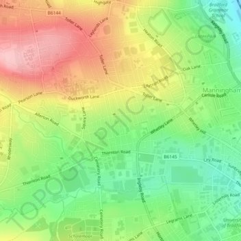
Nom : Carte topographique Girlington, altitude, relief.
Altitude moyenne : 161 m
Altitude minimum : 88 m
Altitude maximum : 245 m
Autres cartes topographiques
Cliquez sur une carte pour visualiser sa topographie, son altitude et son relief.
Sea Moor Dike
United Kingdom > England > West Yorkshire > Bradford > Addingham
Sea Moor Dike, Addingham, Bradford, West Yorkshire, England, LS29 0LH, United Kingdom
Altitude moyenne : 232 m
Broad Folds
United Kingdom > England > West Yorkshire > Bradford > Broad Folds
Broad Folds, Clayton, Bradford, West Yorkshire, England, BD14 6AQ, United Kingdom
Altitude moyenne : 229 m
Haworth, Cross Roads and Stanbury
United Kingdom > England > West Yorkshire > Bradford > Stanbury
Haworth, Cross Roads and Stanbury, Stanbury, Bradford, West Yorkshire, Yorkshire and the Humber, England, United Kingdom
Altitude moyenne : 332 m
Exley Head
United Kingdom > England > West Yorkshire > Bradford > Exley Head
Exley Head, Bradford, West Yorkshire, Yorkshire and the Humber, England, BD22 7EH, United Kingdom
Altitude moyenne : 203 m
Harold Park
United Kingdom > England > West Yorkshire > Bradford
Harold Park, Low Moor, Bradford, West Yorkshire, Yorkshire and the Humber, England, United Kingdom
Altitude moyenne : 208 m