
Carte topographique Finchampstead
Carte interactive
Cliquez sur la carte pour afficher l’altitude.
À propos de cette carte
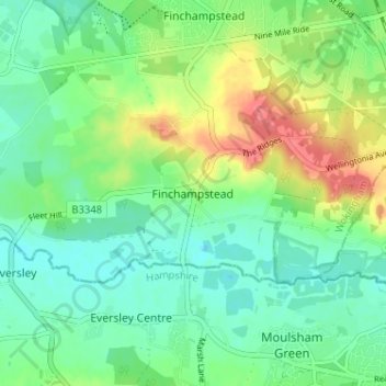
Nom : Carte topographique Finchampstead, altitude, relief.
Altitude moyenne : 65 m
Altitude minimum : 44 m
Altitude maximum : 106 m
Autres cartes topographiques
Cliquez sur une carte pour visualiser sa topographie, son altitude et son relief.
Finchampstead
United Kingdom > England > Finchampstead
Finchampstead, Wokingham, South East, England, RG40 4EE, United Kingdom
Altitude moyenne : 67 m
Colebrook Lake North
United Kingdom > England > Finchampstead
Colebrook Lake North, Finchampstead, Wokingham, South East England, England, United Kingdom
Altitude moyenne : 66 m