
Faire un don
Équipez-vous pour votre prochaine aventure :
En tant que Partenaire Amazon, ce site perçoit une commission sur les achats éligibles sans surcoût pour vous.
Carte topographique Spirit Lake
Cliquez sur la carte pour afficher l’altitude.
Faire un don
Équipez-vous pour votre prochaine aventure :
En tant que Partenaire Amazon, ce site perçoit une commission sur les achats éligibles sans surcoût pour vous.
Spirit Lake
Devils Lake State Park offers 29 miles of hiking trails that vary based on difficulty level, length, and terrain. Among the 17 established trails, the most popular is the tumbled rocks trail. It sits at the edge of the lake on the west end, stretching a mile long. The trail is paved, allowing it to be accessible for people with disabilities or visitors that wish to use a wheelchair, as well as ranked as "easy". Many visitors report to using this trail in order to find a spot to fish from or a rock jump off of. The parks most popular diving rock, Rock 8, can be accessed via the Tumbled Rocks trail. A second trail to highlight is the East Bluff Trail, with multiple overlooks and views, rock formations, and an abundance of wildlife. Rock formations pop up regularly throughout the trail, yet there are special appearances of the. "Elephant Rock" and "Elephant Cave" along the way, two famous landmarks of the park. The trail continues for 1.7 miles, gaining over 500 feet of elevation and is expected to take hikers anywhere between 1.5 to 3 hours to complete.
Faire un don
Équipez-vous pour votre prochaine aventure :
En tant que Partenaire Amazon, ce site perçoit une commission sur les achats éligibles sans surcoût pour vous.
À propos de cette carte
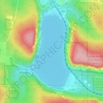
Nom : Carte topographique Spirit Lake, altitude, relief.
Altitude moyenne : 349 m
Altitude minimum : 291 m
Altitude maximum : 448 m
Faire un don
Équipez-vous pour votre prochaine aventure :
En tant que Partenaire Amazon, ce site perçoit une commission sur les achats éligibles sans surcoût pour vous.
Autres cartes topographiques
Cliquez sur une carte pour visualiser sa topographie, son altitude et son relief.
Faire un don
Équipez-vous pour votre prochaine aventure :
En tant que Partenaire Amazon, ce site perçoit une commission sur les achats éligibles sans surcoût pour vous.