
Faire un don
Équipez-vous pour votre prochaine aventure :
En tant que Partenaire Amazon, ce site perçoit une commission sur les achats éligibles sans surcoût pour vous.
Carte topographique Vay
Cliquez sur la carte pour afficher l’altitude.
Faire un don
Équipez-vous pour votre prochaine aventure :
En tant que Partenaire Amazon, ce site perçoit une commission sur les achats éligibles sans surcoût pour vous.
À propos de cette carte
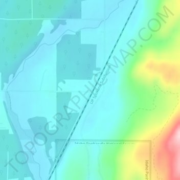
Nom : Carte topographique Vay, altitude, relief.
Lieu : Vay, Bonner County, Idaho, United States (48.10546 -116.78797 48.12546 -116.76797)
Altitude moyenne : 698 m
Altitude minimum : 649 m
Altitude maximum : 895 m
Faire un don
Équipez-vous pour votre prochaine aventure :
En tant que Partenaire Amazon, ce site perçoit une commission sur les achats éligibles sans surcoût pour vous.
Autres cartes topographiques
Cliquez sur une carte pour visualiser sa topographie, son altitude et son relief.
Hope
United States > Idaho > Bonner County
Hope is located at 48°14′55″N 116°18′33″W / 48.24861°N 116.30917°W / 48.24861; -116.30917 (48.248728, -116.309214), at an elevation of 2,192 feet (668 m) above sea level. The city sits on the northeast shore of Lake Pend Oreille.
Altitude moyenne : 763 m
Ponderay
United States > Idaho > Bonner County
Ponderay is located at 48°18′11″N 116°32′18″W / 48.30306°N 116.53833°W / 48.30306; -116.53833 (48.303080, -116.538292), at an elevation of 2,126 feet (648 m) above sea level. According to the United States Census Bureau, the city has a total area of 3.02 square miles (7.82 km2), of which,…
Altitude moyenne : 652 m
Priest River
United States > Idaho > Bonner County
Priest River is located at 48°11′0″N 116°54′34″W / 48.18333°N 116.90944°W / 48.18333; -116.90944 (48.183388, -116.909555), at an elevation of 2,139 feet (652 m) above sea level.
Altitude moyenne : 742 m
Faire un don
Équipez-vous pour votre prochaine aventure :
En tant que Partenaire Amazon, ce site perçoit une commission sur les achats éligibles sans surcoût pour vous.
Oldtown
United States > Idaho > Bonner County
Oldtown is located at 48°11′8″N 117°1′49″W / 48.18556°N 117.03028°W / 48.18556; -117.03028 (48.185623, -117.030158), at an elevation of 2,134 feet (650 meters).
Altitude moyenne : 682 m
Priest River
United States > Idaho > Bonner County
Priest River is located at 48°11′0″N 116°54′34″W / 48.18333°N 116.90944°W / 48.18333; -116.90944 (48.183388, -116.909555), at an elevation of 2,139 feet (652 m) above sea level.
Altitude moyenne : 742 m
Faire un don
Équipez-vous pour votre prochaine aventure :
En tant que Partenaire Amazon, ce site perçoit une commission sur les achats éligibles sans surcoût pour vous.
Clark Fork
United States > Idaho > Bonner County
Clark Fork is located at 48°8′50″N 116°10′42″W / 48.14722°N 116.17833°W / 48.14722; -116.17833 (48.147180, -116.178270), at an elevation of 2,090 feet (637 m) above sea level. The town is situated on the Clark Fork River, on the eastern shores of Lake Pend Oreille. in the northern…
Altitude moyenne : 681 m