
Carte topographique Vagamon
Carte interactive
Cliquez sur la carte pour afficher l’altitude.
À propos de cette carte
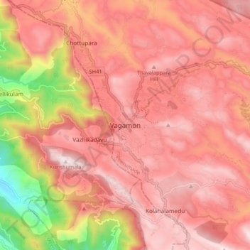
Nom : Carte topographique Vagamon, altitude, relief.
Lieu : Vagamon, Peerumade, Idukki District, Kerala, 685503, India (9.64860 76.86686 9.72860 76.94686)
Altitude moyenne : 866 m
Altitude minimum : 179 m
Altitude maximum : 1 190 m
Vagamon, due to its elevation and climate, has a unique ecosystem, leading to the emergence of rich natural vegetation, plant species, shola forests etc. From the early 20th century plantation crops like tea, coffee started. Vagamon hills are home to less explored flora and fauna. A faunal diversity study conducted by Dr Pratheesh Mathew recorded 112 species of moths from 16 families under eight superfamilies and has become the prominent faunal diversity study in this area. The author has also recorded sightings of many species of insects, annelids, amphibians, lizards, snakes, birds and mammals. A wide variety of flowering and non-flowering plants, including rare Cycas species, has also been noted. The ongoing faunal and floral surveys are expected to shed light on the richness of biodiversity at this location. The flourishing tourism and related developments are predicted to have a negative impact on the flora and fauna of this region.
Autres cartes topographiques
Cliquez sur une carte pour visualiser sa topographie, son altitude et son relief.