
Carte topographique Arizona Falls
Carte interactive
Cliquez sur la carte pour afficher l’altitude.
À propos de cette carte
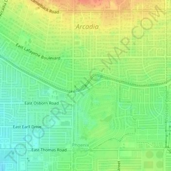
Nom : Carte topographique Arizona Falls, altitude, relief.
Altitude moyenne : 390 m
Altitude minimum : 370 m
Altitude maximum : 414 m
Autres cartes topographiques
Cliquez sur une carte pour visualiser sa topographie, son altitude et son relief.
Phoenix
United States > Arizona > Maricopa County > Phoenix
Phoenix, Maricopa County, Arizona, 85004-1905, United States
Altitude moyenne : 368 m
Desert West Lake
United States > Arizona > Maricopa County > Phoenix
Desert West Lake, 6602, County Fair West, Phoenix, Maricopa County, Arizona, 85035, United States
Altitude moyenne : 330 m
Adobe Dam
United States > Arizona > Maricopa County > Phoenix
Adobe Dam, Deer Valley, Phoenix, Maricopa County, Arizona, United States
Altitude moyenne : 421 m
Camelback Mountain
United States > Arizona > Maricopa County > Phoenix
Camelback Mountain, Phoenix, Maricopa County, Arizona, 85018, United States
Altitude moyenne : 462 m
Chinese Wall
United States > Arizona > Maricopa County > Phoenix
Chinese Wall, Phoenix, Maricopa County, Arizona, 85042, United States
Altitude moyenne : 641 m
Desert Botanical Garden
United States > Arizona > Maricopa County > Phoenix
Desert Botanical Garden, Phoenix, Maricopa County, Arizona, United States
Altitude moyenne : 389 m
New River
United States > Arizona > Maricopa County > Phoenix
New River, Phoenix, Maricopa County, Arizona, United States
Altitude moyenne : 690 m
Union Peak
United States > Arizona > Maricopa County > Phoenix
Union Peak, Phoenix, Maricopa County, Arizona, United States
Altitude moyenne : 527 m
Union Hills
United States > Arizona > Maricopa County > Phoenix
Union Hills, Phoenix, Maricopa County, Arizona, 85024-5118, United States
Altitude moyenne : 506 m