
Faire un don
Équipez-vous pour votre prochaine aventure :
En tant que Partenaire Amazon, ce site perçoit une commission sur les achats éligibles sans surcoût pour vous.
Carte topographique Muskogee
Cliquez sur la carte pour afficher l’altitude.
Faire un don
Équipez-vous pour votre prochaine aventure :
En tant que Partenaire Amazon, ce site perçoit une commission sur les achats éligibles sans surcoût pour vous.
Muskogee
Muskogee lies in the Arkansas River Valley and has a low, sea-level elevation compared to much of the rest of the state. The city is on the boundary of the oak and hickory forest region of eastern Oklahoma and the prairie, Great Plains region of northeastern Oklahoma. It is a suburban community of Tulsa.
Faire un don
Équipez-vous pour votre prochaine aventure :
En tant que Partenaire Amazon, ce site perçoit une commission sur les achats éligibles sans surcoût pour vous.
À propos de cette carte
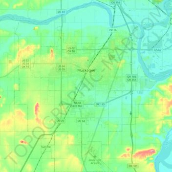
Nom : Carte topographique Muskogee, altitude, relief.
Lieu : Muskogee, Muskogee County, Oklahoma, United States (35.63865 -95.46477 35.82257 -95.27636)
Altitude moyenne : 176 m
Altitude minimum : 145 m
Altitude maximum : 272 m
Faire un don
Équipez-vous pour votre prochaine aventure :
En tant que Partenaire Amazon, ce site perçoit une commission sur les achats éligibles sans surcoût pour vous.