
Faire un don
Équipez-vous pour votre prochaine aventure :
En tant que Partenaire Amazon, ce site perçoit une commission sur les achats éligibles sans surcoût pour vous.
Carte topographique Mountain Mission
Cliquez sur la carte pour afficher l’altitude.
Faire un don
Équipez-vous pour votre prochaine aventure :
En tant que Partenaire Amazon, ce site perçoit une commission sur les achats éligibles sans surcoût pour vous.
À propos de cette carte
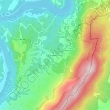
Nom : Carte topographique Mountain Mission, altitude, relief.
Altitude moyenne : 224 m
Altitude minimum : 93 m
Altitude maximum : 459 m
Faire un don
Équipez-vous pour votre prochaine aventure :
En tant que Partenaire Amazon, ce site perçoit une commission sur les achats éligibles sans surcoût pour vous.
Autres cartes topographiques
Cliquez sur une carte pour visualiser sa topographie, son altitude et son relief.
Harpers Ferry
United States > West Virginia > Jefferson County
The town was "easy to seize, and hard to hold", because of its topography: surrounded on three sides by high ground – Bolivar Heights to the west, Loudoun Heights to the south, and Maryland Heights to the east – and surrounded by the Potomac and Shenandoah Rivers, anyone who controlled the heights…
Altitude moyenne : 174 m
Charles Town
United States > West Virginia > Jefferson County
Due to its low elevation for West Virginia, Charles Town is on the northern extent of the Humid Subtropical climate zone, having cool to mildly cold winters and hot and humid summers. Precipitation is evenly distributed throughout the year, providing lush, abundant plant growth.
Altitude moyenne : 150 m
Faire un don
Équipez-vous pour votre prochaine aventure :
En tant que Partenaire Amazon, ce site perçoit une commission sur les achats éligibles sans surcoût pour vous.
Charles Town
United States > West Virginia > Jefferson County
Due to its low elevation for West Virginia, Charles Town is on the northern extent of the Humid Subtropical climate zone, having cool to mildly cold winters and hot and humid summers. Precipitation is evenly distributed throughout the year, providing lush, abundant plant growth.
Altitude moyenne : 150 m
Harpers Ferry
United States > West Virginia > Jefferson County
The town was "easy to seize, and hard to hold", because of its topography: surrounded on three sides by high ground (Bolivar Heights to the west, Loudoun Heights to the south, and Maryland Heights to the east) and the Potomac and Shenandoah Rivers, anyone who controlled the heights controlled the city.
Altitude moyenne : 174 m
Faire un don
Équipez-vous pour votre prochaine aventure :
En tant que Partenaire Amazon, ce site perçoit une commission sur les achats éligibles sans surcoût pour vous.
Harpers Ferry
United States > West Virginia > Jefferson County
The town was "easy to seize, and hard to hold", because of its topography: surrounded on three sides by high ground (Bolivar Heights to the west, Loudoun Heights to the south, and Maryland Heights to the east) and the Potomac and Shenandoah Rivers, anyone who controlled the heights controlled the city.
Altitude moyenne : 174 m