
Faire un don
Équipez-vous pour votre prochaine aventure :
En tant que Partenaire Amazon, ce site perçoit une commission sur les achats éligibles sans surcoût pour vous.
Carte topographique Surry
Cliquez sur la carte pour afficher l’altitude.
Faire un don
Équipez-vous pour votre prochaine aventure :
En tant que Partenaire Amazon, ce site perçoit une commission sur les achats éligibles sans surcoût pour vous.
Surry
The National Weather Service in Caribou established a cooperative weather station at East Surry in July 2007. The NWS station, named Ellsworth-3SSW, serves as an official meteorological recording site, providing daily weather and climate information to the (NWS) National Weather Service, (NCDC) National Climatic Data Center, CoCoRaHS (Community Collaborative Rain, Hail and Snow Network), and CWOP (Citizens Weather Observer Program). The station (Ellsworth-3SSW) continues the climate history of Ellsworth dating back to the 1930s. The cooperative station is located at an elevation of 105 feet, approximately two miles east of Surry village.
Faire un don
Équipez-vous pour votre prochaine aventure :
En tant que Partenaire Amazon, ce site perçoit une commission sur les achats éligibles sans surcoût pour vous.
À propos de cette carte
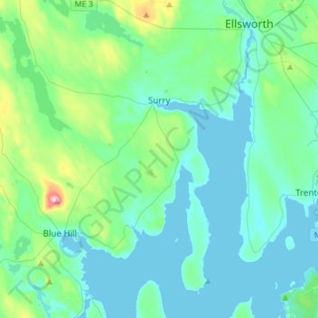
Nom : Carte topographique Surry, altitude, relief.
Lieu : Surry, Hancock County, Maine, 04684, United States (44.36204 -68.62552 44.55695 -68.42880)
Altitude moyenne : 43 m
Altitude minimum : -2 m
Altitude maximum : 279 m
Faire un don
Équipez-vous pour votre prochaine aventure :
En tant que Partenaire Amazon, ce site perçoit une commission sur les achats éligibles sans surcoût pour vous.
Autres cartes topographiques
Cliquez sur une carte pour visualiser sa topographie, son altitude et son relief.
Cadillac Mountain
United States > Maine > Hancock County > Bar Harbor
Cadillac Mountain is located on Mount Desert Island, within Acadia National Park, in the U.S. state of Maine. With an elevation of nearly 1,530 feet (470 meters), its summit is the highest point in Hancock County and the highest within 25 miles (40 km) of the Atlantic shoreline of the North American continent…
Altitude moyenne : 233 m
Faire un don
Équipez-vous pour votre prochaine aventure :
En tant que Partenaire Amazon, ce site perçoit une commission sur les achats éligibles sans surcoût pour vous.
Cadillac Mountain
United States > Maine > Hancock County > Bar Harbor
Cadillac Mountain is located on Mount Desert Island, within Acadia National Park, in the U.S. state of Maine. With an elevation of 1,530 feet (470 meters), its summit is the highest point in Hancock County and the highest within 25 miles (40 km) of the Atlantic shoreline of the North American continent between…
Altitude moyenne : 233 m
Faire un don
Équipez-vous pour votre prochaine aventure :
En tant que Partenaire Amazon, ce site perçoit une commission sur les achats éligibles sans surcoût pour vous.
Faire un don
Équipez-vous pour votre prochaine aventure :
En tant que Partenaire Amazon, ce site perçoit une commission sur les achats éligibles sans surcoût pour vous.
Faire un don
Équipez-vous pour votre prochaine aventure :
En tant que Partenaire Amazon, ce site perçoit une commission sur les achats éligibles sans surcoût pour vous.