
Carte topographique Husum
Carte interactive
Cliquez sur la carte pour afficher l’altitude.
À propos de cette carte
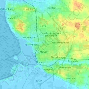
Nom : Carte topographique Husum, altitude, relief.
Lieu : Husum, Northern Friesland, Schleswig-Holstein, 25813, Germany (54.45842 8.95897 54.52546 9.10165)
Altitude moyenne : 8 m
Altitude minimum : -4 m
Altitude maximum : 32 m
Autres cartes topographiques
Cliquez sur une carte pour visualiser sa topographie, son altitude et son relief.
Langeneß
Germany > Schleswig-Holstein > Northern Friesland > Langeneß
Langeneß, Pellworm, Northern Friesland, Schleswig-Holstein, 25863, Germany
Altitude moyenne : 0 m
Dagebüll
Germany > Schleswig-Holstein > Northern Friesland
Dagebüll, Südtondern, Northern Friesland, Schleswig-Holstein, Germany
Altitude moyenne : 0 m
Neukirchen
Germany > Schleswig-Holstein > Northern Friesland
Neukirchen, Südtondern, Northern Friesland, Schleswig-Holstein, 25927, Germany
Altitude moyenne : 0 m
Sankt Peter-Ording
Germany > Schleswig-Holstein > Northern Friesland
Sankt Peter-Ording, Eiderstedt, Northern Friesland, Schleswig-Holstein, 25826, Germany
Altitude moyenne : 0 m
Broweg
Germany > Schleswig-Holstein > Northern Friesland > Stedesand
Broweg, Stedesand, Südtondern, Northern Friesland, Schleswig-Holstein, 25920, Germany
Altitude moyenne : 1 m
Garding
Germany > Schleswig-Holstein > Northern Friesland
Garding, Eiderstedt, Northern Friesland, Schleswig-Holstein, 25836, Germany
Altitude moyenne : 0 m
Hörnum (Sylt)
Germany > Schleswig-Holstein > Northern Friesland
Hörnum (Sylt), Landschaft Sylt, Northern Friesland, Schleswig-Holstein, 25997, Germany
Altitude moyenne : 1 m
Westerland
Germany > Schleswig-Holstein > Northern Friesland > Sylt
Westerland, Sylt, Northern Friesland, Schleswig-Holstein, Germany
Altitude moyenne : 3 m
Nordstrand
Germany > Schleswig-Holstein > Northern Friesland
Nordstrand, Nordsee-Treene, Northern Friesland, Schleswig-Holstein, 25845, Germany
Altitude moyenne : -1 m
Sylt
Germany > Schleswig-Holstein > Northern Friesland
Sylt, Northern Friesland, Schleswig-Holstein, Germany
Altitude moyenne : 0 m