
Carte topographique Llanboidy
Carte interactive
Cliquez sur la carte pour afficher l’altitude.
À propos de cette carte
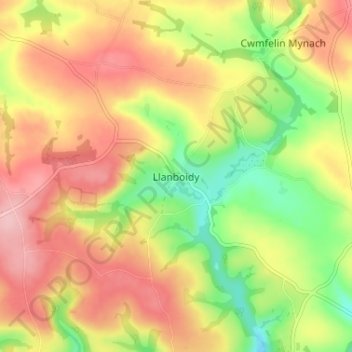
Nom : Carte topographique Llanboidy, altitude, relief.
Lieu : Llanboidy, Carmarthenshire, Wales, SA34 0EL, United Kingdom (51.85885 -4.61297 51.89885 -4.57297)
Altitude moyenne : 137 m
Altitude minimum : 58 m
Altitude maximum : 204 m
Autres cartes topographiques
Cliquez sur une carte pour visualiser sa topographie, son altitude et son relief.
Aber-Arad
United Kingdom > Wales > Carmarthenshire
Aber-Arad, Carmarthenshire, Wales, SA38 9DW, United Kingdom
Altitude moyenne : 107 m
Llansadwrn
United Kingdom > Wales > Carmarthenshire
Llansadwrn, Carmarthenshire, Wales, SA19 8LE, United Kingdom
Altitude moyenne : 120 m
Llandeilo
United Kingdom > Wales > Carmarthenshire
Llandeilo, Carmarthenshire, Wales, SA19 6EB, United Kingdom
Altitude moyenne : 102 m
Pencader
United Kingdom > Wales > Carmarthenshire
Pencader, Carmarthenshire, Wales, SA39 9HF, United Kingdom
Altitude moyenne : 182 m
Llanelli
United Kingdom > Wales > Carmarthenshire > Llanelli
Llanelli, Carmarthenshire, Wales, SA15 1SA, United Kingdom
Altitude moyenne : 41 m
Login
United Kingdom > Wales > Carmarthenshire > Login
Login, Carmarthenshire, Wales, SA34 0XB, United Kingdom
Altitude moyenne : 127 m
Llanybri
United Kingdom > Wales > Carmarthenshire
Llanybri, Carmarthenshire, Wales, SA33 5HF, United Kingdom
Altitude moyenne : 67 m
Llansteffan
United Kingdom > Wales > Carmarthenshire
Llansteffan, Carmarthenshire, Wales, SA33 5JG, United Kingdom
Altitude moyenne : 46 m