
Carte topographique Wake Island
Carte interactive
Cliquez sur la carte pour afficher l’altitude.
À propos de cette carte
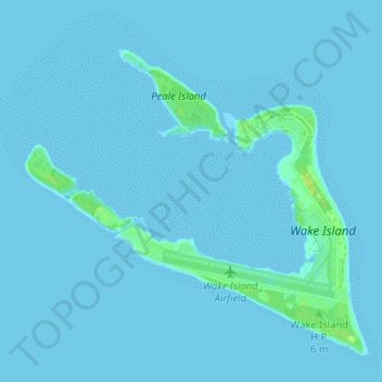
Nom : Carte topographique Wake Island, altitude, relief.
Lieu : Wake Island, United States (19.26768 166.59448 19.32448 166.65878)
Altitude moyenne : 1 m
Altitude minimum : 0 m
Altitude maximum : 16 m
Wake is an atoll composed of three islands in a V shape that encloses a shallow lagoon, with a size of 3.3 by 7.7 km, with a highest elevation of 6.4 meters above sea level. The island is ringed by a wide sandy beach of about 90 yards wide, with an offshore fringing reef. The average elevation of the islands is about 3–4 meters. The total land area of the islands is about 6.5 km2 (2.5 miles2).
Autres cartes topographiques
Cliquez sur une carte pour visualiser sa topographie, son altitude et son relief.
Everett
United States > Washington > Snohomish County
Everett, Snohomish County, Washington, United States
Altitude moyenne : 66 m
Fargo
United States > North Dakota > Cass County
Fargo, Cass County, North Dakota, United States
Altitude moyenne : 277 m
Beaverton
United States > Oregon > Washington County
Beaverton, Washington County, Oregon, United States
Altitude moyenne : 106 m
Wake County
United States > North Carolina
Wake County, North Carolina, United States
Altitude moyenne : 96 m
Baltimore County
Baltimore County, Maryland, United States
Altitude moyenne : 123 m
Camp Kingsmont
United States > Massachusetts > Berkshire County > West Stockbridge
Camp Kingsmont, West Stockbridge, Berkshire County, Massachusetts, 01266, United States
Altitude moyenne : 421 m
Puyallup
United States > Washington > Pierce County
Puyallup, Pierce County, Washington, United States
Altitude moyenne : 66 m
Lynnwood
United States > Washington > Snohomish County
Lynnwood, Snohomish County, Washington, 98037, United States
Altitude moyenne : 121 m
Saint Louis County
Saint Louis County, Missouri, United States
Altitude moyenne : 166 m
Halls Creek
United States > Wisconsin > Florence County > Town of Commonwealth
Halls Creek, Town of Commonwealth, Florence County, Wisconsin, 54121, United States
Altitude moyenne : 384 m
West Orange
United States > New Jersey > Essex County
West Orange, Essex County, New Jersey, 07052, United States
Altitude moyenne : 108 m
Lamb Island
United States > Alaska > Kodiak Island
Lamb Island, Kodiak Island, Alaska, United States
Altitude moyenne : 1 m
Litchfield County
United States > Connecticut > Northwest Hills Planning Region
Litchfield County, Northwest Hills Planning Region, Connecticut, United States
Altitude moyenne : 252 m
Moore County
United States > North Carolina
Moore County, North Carolina, United States
Altitude moyenne : 127 m
Edenburg
United States > Pennsylvania > Berks County > Windsor Township
Edenburg, Windsor Township, Berks County, Pennsylvania, 19526, United States
Altitude moyenne : 184 m
Borger
United States > Texas > Hutchinson County
Borger, Hutchinson County, Texas, 79007, United States
Altitude moyenne : 929 m
Camden
United States > New Jersey > Camden County
Camden, Camden County, New Jersey, United States
Altitude moyenne : 7 m
The Lakes
United States > Georgia > Camden County > Kingsland
The Lakes, Kingsland, Camden County, Georgia, 31548, United States
Altitude moyenne : 7 m
Fort Liberty
United States > North Carolina > Hoke County
Fort Liberty, Hoke County, North Carolina, United States
Altitude moyenne : 88 m
Roseville
United States > California > Placer County
Roseville, Placer County, California, United States
Altitude moyenne : 61 m
Mililani Town
United States > Hawaii > Honolulu County
Mililani Town, Honolulu County, Hawaii, 96789, United States
Altitude moyenne : 183 m
Austin
United States > Minnesota > Mower County
Austin, Mower County, Minnesota, 55912, United States
Altitude moyenne : 374 m
Keating Township
United States > Pennsylvania > McKean County
Keating Township, McKean County, Pennsylvania, United States
Altitude moyenne : 589 m
Honey Hill
United States > North Carolina > Caldwell County > Lenoir
Honey Hill, Lenoir, Caldwell County, North Carolina, 28645, United States
Altitude moyenne : 360 m
Ocean County
Ocean County, New Jersey, United States
Altitude moyenne : 15 m
Largo
United States > Florida > Pinellas County
Largo, Pinellas County, Florida, United States
Altitude moyenne : 9 m
Redwood City
United States > California > San Mateo County
Redwood City, San Mateo County, California, United States
Altitude moyenne : 32 m
Gillis
United States > California > San Joaquin County
Gillis, San Joaquin County, California, 95203, United States
Altitude moyenne : -1 m
Orchard Hill
United States > Georgia > Spalding County
Orchard Hill, Spalding County, Georgia, United States
Altitude moyenne : 253 m
Mesquite
United States > Texas > Dallas County
Mesquite, Dallas County, Texas, United States
Altitude moyenne : 142 m
Beacon Hill
United States > Massachusetts > Suffolk County > Boston
Beacon Hill, Boston, Suffolk County, Massachusetts, United States
Altitude moyenne : 11 m
Cameron
United States > Missouri > Clinton County
Cameron, Clinton County, Missouri, 64429, United States
Altitude moyenne : 301 m
Miller Place
United States > New York > Suffolk County > Town of Brookhaven
Miller Place, Town of Brookhaven, Suffolk County, New York, 11764, United States
Altitude moyenne : 34 m
Orient
United States > New York > Suffolk County > Town of Southold
Orient, Town of Southold, Suffolk County, New York, United States
Altitude moyenne : 2 m
Taylor County
Taylor County, West Virginia, United States
Altitude moyenne : 420 m
Hickory
United States > North Carolina > Catawba County
Hickory, Catawba County, North Carolina, United States
Altitude moyenne : 317 m
North Branford
United States > Connecticut > South Central Connecticut Planning Region
North Branford, South Central Connecticut Planning Region, Connecticut, United States
Altitude moyenne : 68 m
Fairbanks North Star
Fairbanks North Star, Alaska, United States
Altitude moyenne : 528 m
Downey
United States > Idaho > Bannock County
Downey, Bannock County, Idaho, 83234, United States
Altitude moyenne : 1 482 m
Hennepin County
Hennepin County, Minnesota, United States
Altitude moyenne : 280 m
Dade City
United States > Florida > Pasco County
Dade City, Pasco County, Florida, United States
Altitude moyenne : 33 m
The Branch
United States > New Hampshire > Cheshire County > Keene > South Keene
The Branch, South Keene, Keene, Cheshire County, New Hampshire, United States
Altitude moyenne : 181 m
City of Auburn
United States > New York > Cayuga County
City of Auburn, Cayuga County, New York, 13021, United States
Altitude moyenne : 209 m
Linden Springs
United States > Maryland > Baltimore County
Linden Springs, Baltimore County, Maryland, 21053, United States
Altitude moyenne : 253 m
Cutler Creek
United States > Colorado > Ouray County
Cutler Creek, Ouray County, Colorado, United States
Altitude moyenne : 2 654 m
West Jefferson
United States > North Carolina > Ashe County
West Jefferson, Ashe County, North Carolina, United States
Altitude moyenne : 1 002 m