
Faire un don
Équipez-vous pour votre prochaine aventure :
En tant que Partenaire Amazon, ce site perçoit une commission sur les achats éligibles sans surcoût pour vous.
Carte topographique Flint
Cliquez sur la carte pour afficher l’altitude.
Faire un don
Équipez-vous pour votre prochaine aventure :
En tant que Partenaire Amazon, ce site perçoit une commission sur les achats éligibles sans surcoût pour vous.
À propos de cette carte
Nom : Carte topographique Flint, altitude, relief.
Altitude moyenne : 279 m
Altitude minimum : 228 m
Altitude maximum : 299 m
Faire un don
Équipez-vous pour votre prochaine aventure :
En tant que Partenaire Amazon, ce site perçoit une commission sur les achats éligibles sans surcoût pour vous.
Autres cartes topographiques
Cliquez sur une carte pour visualiser sa topographie, son altitude et son relief.
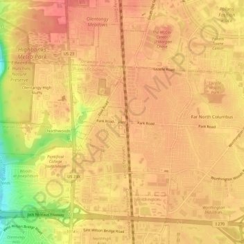
Columbus
United States > Ohio > Franklin County
Columbus is situated in the rolling hills of the Central Lowlands region, characterized by a predominantly flat to gently undulating terrain. The city itself is nestled on the banks of the Scioto River, which flows northward through the area, providing a picturesque waterfront and a variety of recreational…
Altitude moyenne : 261 m
Faire un don
Équipez-vous pour votre prochaine aventure :
En tant que Partenaire Amazon, ce site perçoit une commission sur les achats éligibles sans surcoût pour vous.
Upper Arlington
United States > Ohio > Franklin County
The city is around 800 ft elevation located between the Olentangy and Scioto rivers. Two ravines cut through the city. The Slate Run in the northwest corner flows into the Scioto River. However, the Turkey Run is longer. It originates in the north then runs southwards until it makes an eastward bend around…
Altitude moyenne : 249 m
Faire un don
Équipez-vous pour votre prochaine aventure :
En tant que Partenaire Amazon, ce site perçoit une commission sur les achats éligibles sans surcoût pour vous.
New Albany
United States > Ohio > Franklin County
New Albany is located in northeastern Franklin County at 40°4′43″N 82°49′14″W / 40.07861°N 82.82056°W / 40.07861; -82.82056 (40.078643, −82.820618), with a portion extending east into Licking County. It is northeast of Columbus at an elevation of 1,024 feet (312 m).
Altitude moyenne : 315 m
Faire un don
Équipez-vous pour votre prochaine aventure :
En tant que Partenaire Amazon, ce site perçoit une commission sur les achats éligibles sans surcoût pour vous.
Dublin
United States > Ohio > Franklin County
Located on the Glaciated Allegheny Plateau, Dublin has a relatively flat topography. Nevertheless, there are numerous ravines surrounding the tributaries of the Scioto River, which make for steep cliffs in some areas. Elevations range from 780 feet (240 m) above sea level where the Scioto River leaves the city…
Altitude moyenne : 275 m
Columbus
United States > Ohio > Franklin County
The confluence of the Scioto and Olentangy rivers is just northwest of Downtown Columbus. Several smaller tributaries course through the Columbus metropolitan area, including Alum Creek, Big Walnut Creek and Darby Creek. Columbus is considered to have relatively flat topography thanks to a large glacier that…
Altitude moyenne : 261 m
Faire un don
Équipez-vous pour votre prochaine aventure :
En tant que Partenaire Amazon, ce site perçoit une commission sur les achats éligibles sans surcoût pour vous.
Columbus
United States > Ohio > Franklin County
The confluence of the Scioto and Olentangy rivers is just northwest of Downtown Columbus. Several smaller tributaries course through the Columbus metropolitan area, including Alum Creek, Big Walnut Creek and Darby Creek. Columbus is considered to have relatively flat topography thanks to a large glacier that…
Altitude moyenne : 261 m
Faire un don
Équipez-vous pour votre prochaine aventure :
En tant que Partenaire Amazon, ce site perçoit une commission sur les achats éligibles sans surcoût pour vous.
Columbus
United States > Ohio > Franklin County
The confluence of the Scioto and Olentangy rivers is just northwest of Downtown Columbus. Several smaller tributaries course through the Columbus metropolitan area, including Alum Creek, Big Walnut Creek and Darby Creek. Columbus is considered to have relatively flat topography thanks to a large glacier that…
Altitude moyenne : 261 m
Faire un don
Équipez-vous pour votre prochaine aventure :
En tant que Partenaire Amazon, ce site perçoit une commission sur les achats éligibles sans surcoût pour vous.
Faire un don
Équipez-vous pour votre prochaine aventure :
En tant que Partenaire Amazon, ce site perçoit une commission sur les achats éligibles sans surcoût pour vous.
Columbus
United States > Ohio > Franklin County
The confluence of the Scioto and Olentangy rivers is just northwest of Downtown Columbus. Several smaller tributaries course through the Columbus metropolitan area, including Alum Creek, Big Walnut Creek and Darby Creek. Columbus is considered to have relatively flat topography thanks to a large glacier that…
Altitude moyenne : 261 m
Faire un don
Équipez-vous pour votre prochaine aventure :
En tant que Partenaire Amazon, ce site perçoit une commission sur les achats éligibles sans surcoût pour vous.
Columbus
United States > Ohio > Franklin County
The confluence of the Scioto and Olentangy rivers is just northwest of Downtown Columbus. Several smaller tributaries course through the Columbus metropolitan area, including Alum Creek, Big Walnut Creek and Darby Creek. Columbus is considered to have relatively flat topography thanks to a large glacier that…
Altitude moyenne : 261 m
Faire un don
Équipez-vous pour votre prochaine aventure :
En tant que Partenaire Amazon, ce site perçoit une commission sur les achats éligibles sans surcoût pour vous.
Faire un don
Équipez-vous pour votre prochaine aventure :
En tant que Partenaire Amazon, ce site perçoit une commission sur les achats éligibles sans surcoût pour vous.
Columbus
United States > Ohio > Franklin County
The confluence of the Scioto and Olentangy rivers is just northwest of Downtown Columbus. Several smaller tributaries course through the Columbus metropolitan area, including Alum Creek, Big Walnut Creek and Darby Creek. Columbus is considered to have relatively flat topography thanks to a large glacier that…
Altitude moyenne : 261 m