
Faire un don
Équipez-vous pour votre prochaine aventure :
En tant que Partenaire Amazon, ce site perçoit une commission sur les achats éligibles sans surcoût pour vous.
Carte topographique McClurg
Cliquez sur la carte pour afficher l’altitude.
Faire un don
Équipez-vous pour votre prochaine aventure :
En tant que Partenaire Amazon, ce site perçoit une commission sur les achats éligibles sans surcoût pour vous.
À propos de cette carte
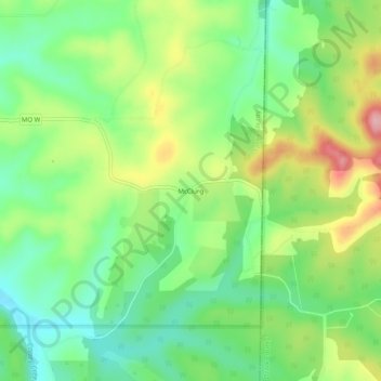
Nom : Carte topographique McClurg, altitude, relief.
Lieu : McClurg, Taney County, Missouri, United States (36.76450 -92.79489 36.80450 -92.75489)
Altitude moyenne : 347 m
Altitude minimum : 286 m
Altitude maximum : 443 m
Faire un don
Équipez-vous pour votre prochaine aventure :
En tant que Partenaire Amazon, ce site perçoit une commission sur les achats éligibles sans surcoût pour vous.
Autres cartes topographiques
Cliquez sur une carte pour visualiser sa topographie, son altitude et son relief.
Branson
United States > Missouri > Taney County
Branson features a diverse and picturesque topography characterized by rolling hills, deep valleys, and abundant water features. Nestled in the Ozark Mountains, the area has an elevation that typically ranges around 778 feet (237 meters) above sea level. The region is shaped by its proximity to several lakes,…
Altitude moyenne : 275 m
Taneyville
United States > Missouri > Taney County
Taneyville is located in north-central Taney County. The town lies along Missouri Route 76 between Bradleyville and Kissee Mills. The townsite is on a northeast–southwest trending ridge between Swan Creek to the northwest and Beaver Creek to the southeast. The site is at an elevation of 1,073 ft (327 m).
Altitude moyenne : 312 m
Faire un don
Équipez-vous pour votre prochaine aventure :
En tant que Partenaire Amazon, ce site perçoit une commission sur les achats éligibles sans surcoût pour vous.
Silver Dollar City's WhiteWater
United States > Missouri > Taney County > Branson
Altitude moyenne : 296 m
Faire un don
Équipez-vous pour votre prochaine aventure :
En tant que Partenaire Amazon, ce site perçoit une commission sur les achats éligibles sans surcoût pour vous.
Faire un don
Équipez-vous pour votre prochaine aventure :
En tant que Partenaire Amazon, ce site perçoit une commission sur les achats éligibles sans surcoût pour vous.