
Faire un don
Équipez-vous pour votre prochaine aventure :
En tant que Partenaire Amazon, ce site perçoit une commission sur les achats éligibles sans surcoût pour vous.
Carte topographique Carlisle
Cliquez sur la carte pour afficher l’altitude.
Faire un don
Équipez-vous pour votre prochaine aventure :
En tant que Partenaire Amazon, ce site perçoit une commission sur les achats éligibles sans surcoût pour vous.
Carlisle
Carlisle is located slightly northeast of the center of Cumberland County at 40°12′9″N 77°11′42″W / 40.20250°N 77.19500°W / 40.20250; -77.19500 (40.202553, −77.195016) at an elevation of 479 feet (146 m).[24][25] The borough lies in the Cumberland Valley, a section of the Great Appalachian Valley, to the south of Conodoguinet Creek, a tributary of the Susquehanna River. Letort Spring Run, a tributary of Conodoguinet Creek, runs north through the eastern part of the borough.
Faire un don
Équipez-vous pour votre prochaine aventure :
En tant que Partenaire Amazon, ce site perçoit une commission sur les achats éligibles sans surcoût pour vous.
À propos de cette carte
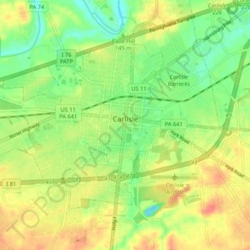
Nom : Carte topographique Carlisle, altitude, relief.
Altitude moyenne : 148 m
Altitude minimum : 122 m
Altitude maximum : 176 m
Faire un don
Équipez-vous pour votre prochaine aventure :
En tant que Partenaire Amazon, ce site perçoit une commission sur les achats éligibles sans surcoût pour vous.
Autres cartes topographiques
Cliquez sur une carte pour visualiser sa topographie, son altitude et son relief.
Carlisle Springs
United States > Pennsylvania > Cumberland County > Middlesex Township
Altitude moyenne : 182 m
Lees Cross Roads
United States > Pennsylvania > Cumberland County > Southampton Township
Altitude moyenne : 238 m
Pine Grove Furnace
United States > Pennsylvania > Cumberland County > Cooke Township
Altitude moyenne : 332 m
Mount Zion
United States > Pennsylvania > Cumberland County > South Middleton Township
Altitude moyenne : 179 m
Faire un don
Équipez-vous pour votre prochaine aventure :
En tant que Partenaire Amazon, ce site perçoit une commission sur les achats éligibles sans surcoût pour vous.
Carlisle Springs
United States > Pennsylvania > Cumberland County > Middlesex Township
Altitude moyenne : 182 m
Chestnut Crossroads
United States > Pennsylvania > Cumberland County > Southampton Township
Altitude moyenne : 256 m
Green Spring
United States > Pennsylvania > Cumberland County > North Newton Township
Altitude moyenne : 174 m
Treemont
United States > Pennsylvania > Cumberland County > East Pennsboro Township
Altitude moyenne : 162 m
Faire un don
Équipez-vous pour votre prochaine aventure :
En tant que Partenaire Amazon, ce site perçoit une commission sur les achats éligibles sans surcoût pour vous.
Caprivi
United States > Pennsylvania > Cumberland County > North Middleton Township
Altitude moyenne : 156 m
Springville
United States > Pennsylvania > Cumberland County > South Middleton Township
Altitude moyenne : 162 m
Liebys Trailer Park
United States > Pennsylvania > Cumberland County > Liebys Trailer Park
Altitude moyenne : 138 m
Drexel Hills
United States > Pennsylvania > Cumberland County > New Cumberland
Altitude moyenne : 111 m
Faire un don
Équipez-vous pour votre prochaine aventure :
En tant que Partenaire Amazon, ce site perçoit une commission sur les achats éligibles sans surcoût pour vous.