
Faire un don
Équipez-vous pour votre prochaine aventure :
En tant que Partenaire Amazon, ce site perçoit une commission sur les achats éligibles sans surcoût pour vous.
Carte topographique Harris
Cliquez sur la carte pour afficher l’altitude.
Faire un don
Équipez-vous pour votre prochaine aventure :
En tant que Partenaire Amazon, ce site perçoit une commission sur les achats éligibles sans surcoût pour vous.
À propos de cette carte
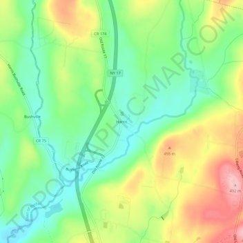
Nom : Carte topographique Harris, altitude, relief.
Altitude moyenne : 396 m
Altitude minimum : 334 m
Altitude maximum : 489 m
Faire un don
Équipez-vous pour votre prochaine aventure :
En tant que Partenaire Amazon, ce site perçoit une commission sur les achats éligibles sans surcoût pour vous.
Autres cartes topographiques
Cliquez sur une carte pour visualiser sa topographie, son altitude et son relief.
Town of Mamakating
United States > New York > Sullivan County
The highest elevation in the town is 1,648 feet (502 m), near the junction of Mamakating Avenue and Park Road in the Mamakating Park Historic District. The lowest elevation is 340 feet (100 m), at the tripoint with Orange and Ulster counties where the Bush Kill drains into the Shawangunkill.
Altitude moyenne : 316 m
Shawangunk Ridge
United States > New York > Sullivan County
The ridge is widest (7.5 miles (12.1 km)) near the northern end and narrow in the middle (1.25 miles (2.01 km)), with a maximum elevation of 2,289 feet (698 m) near Lake Maratanza. The ridge rises above a broad, high plain which stretches to the Hudson River to the east. On the west the low foothills of the…
Altitude moyenne : 256 m
Faire un don
Équipez-vous pour votre prochaine aventure :
En tant que Partenaire Amazon, ce site perçoit une commission sur les achats éligibles sans surcoût pour vous.
Town of Fremont
United States > New York > Sullivan County
The climate of the town is typical of the interior northeast. Made up of hills of about 2,000 ft. in elevation and valleys under 1,000 ft. The majority of the town is forested with open fields scattered about.
Altitude moyenne : 484 m
Faire un don
Équipez-vous pour votre prochaine aventure :
En tant que Partenaire Amazon, ce site perçoit une commission sur les achats éligibles sans surcoût pour vous.
Grahamsville
United States > New York > Sullivan County > Town of Neversink
Grahamsville is located at latitude 41.848 and longitude -74.548. The elevation is 968 feet. Grahamsville is in the Eastern Time Zone.
Altitude moyenne : 397 m
Lake Huntington
United States > New York > Sullivan County > Town of Cochecton
Altitude moyenne : 381 m
Faire un don
Équipez-vous pour votre prochaine aventure :
En tant que Partenaire Amazon, ce site perçoit une commission sur les achats éligibles sans surcoût pour vous.
Evens Lake
United States > New York > Sullivan County > Town of Fallsburg > Loch Sheldrake
Altitude moyenne : 443 m
Faire un don
Équipez-vous pour votre prochaine aventure :
En tant que Partenaire Amazon, ce site perçoit une commission sur les achats éligibles sans surcoût pour vous.