

Carte topographique Indore
Cliquez sur la carte pour afficher l’altitude.
Indore
Indore /ɪnˈdɔːr/ (listen) is the most populous and the largest city in the Indian state of Madhya Pradesh. It serves as the headquarters of both Indore District and Indore Division. It is also considered as an education hub of the state and has campuses of both the Indian Institute of Technology and the Indian Institute of Management. Located on the southern edge of Malwa Plateau, at an average altitude of 550 meters (1,800 ft) above sea level, it has the highest elevation among major cities of Central India. The city is 190 km (120 mi) west of the state capital of Bhopal. Indore had a census-estimated 2011 population of 1,994,397 (municipal corporation) and 2,170,295 (urban agglomeration). The city is distributed over a land area of just 530 square kilometres (200 sq mi), making Indore the most densely populated major city in the central province. It comes under Tier 2 cities in India.
À propos de cette carte
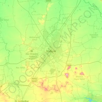
Nom : Carte topographique Indore, altitude, relief.
Altitude moyenne : 555 m
Altitude minimum : 445 m
Altitude maximum : 775 m
Autres cartes topographiques
Cliquez sur une carte pour visualiser sa topographie, son altitude et son relief.

Siddheshwar Hanuman Mandir Udyaan
India > Madhya Pradesh > Juni Indore Tahsil > Indore
Altitude moyenne : 550 m

